IMAGES TAKEN NEAR TO
Windmill Green, LEEDS, LS26 0DP
Introduction
This page details the photographs taken nearby to Windmill Green, LS26 0DP by members of the Geograph project.
The Geograph project started in 2005 with the aim of publishing, organising and preserving representative images for every square kilometre of Great Britain, Ireland and the Isle of Man.

There are currently over 7.5m images from over14,400 individuals and you can help contribute to the project by visiting https://www.geograph.org.uk
Image Map (Loading...)


Getting Data...Please wait
Leaflet Map data © OpenStreetMap
Images are licensed for reuse under creativecommons.org/licenses/by-sa/2.0
Notes
- Clicking on the map will re-center to the selected point.
- The higher the marker number, the further away the image location is from the centre of the postcode.
Image Listing (166 Images Found)
Images are licensed for reuse under creativecommons.org/licenses/by-sa/2.0
Image
Details
Distance
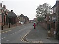
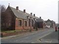
1
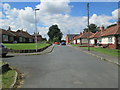
Windmill Green - looking towards Windmill Lane
Image: © Betty Longbottom
Taken: 30 Jun 2014
0.01 miles
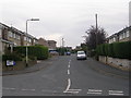
3
Windmill Lane - viewed from Windmill Field Road
Image: © Betty Longbottom
Taken: 30 Jun 2014
0.05 miles
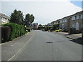
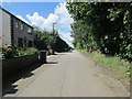
4
Windmill Field Road - viewed from Windmill Lane
Image: © Betty Longbottom
Taken: 30 Jun 2014
0.05 miles
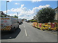
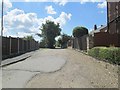
6
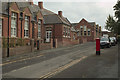
Windmill Lane, Rothwell
A closer view of the postbox can be seen here: Image
Image: © Mark Anderson
Taken: 21 Oct 2016
0.05 miles