IMAGES TAKEN NEAR TO
Fairfield Link, LEEDS, LS25 6LT
Introduction
This page details the photographs taken nearby to Fairfield Link, LS25 6LT by members of the Geograph project.
The Geograph project started in 2005 with the aim of publishing, organising and preserving representative images for every square kilometre of Great Britain, Ireland and the Isle of Man.

There are currently over 7.5m images from over14,400 individuals and you can help contribute to the project by visiting https://www.geograph.org.uk
Image Map
Images are licensed for reuse under creativecommons.org/licenses/by-sa/2.0
Notes
- Clicking on the map will re-center to the selected point.
- The higher the marker number, the further away the image location is from the centre of the postcode.
Image Listing (46 Images Found)
Images are licensed for reuse under creativecommons.org/licenses/by-sa/2.0
Image
Details
Distance
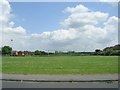
1
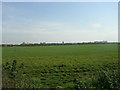
Open Field - end of Fairfield Link
Image: © Betty Longbottom
Taken: 24 Oct 2011
0.01 miles
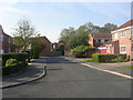
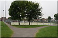
2
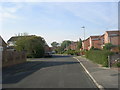
Fairfield Link - looking towards The Fairway
Image: © Betty Longbottom
Taken: 24 Oct 2011
0.03 miles
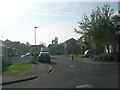
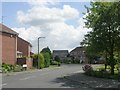
5
Fairway Close - looking towards The Fairway
Image: © Betty Longbottom
Taken: 24 Oct 2011
0.08 miles
6
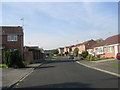
Carousel Walk - looking towards The Fairway
Image: © Betty Longbottom
Taken: 24 Oct 2011
0.08 miles
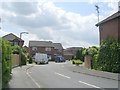
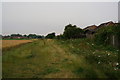
10
Football pitch on Pasture Way, Sherburn in Elmet
Image: © Ian S
Taken: 23 Jul 2014
0.10 miles