IMAGES TAKEN NEAR TO
Huddleston, LEEDS, LS25 6JU
Introduction
This page details the photographs taken nearby to Huddleston, LS25 6JU by members of the Geograph project.
The Geograph project started in 2005 with the aim of publishing, organising and preserving representative images for every square kilometre of Great Britain, Ireland and the Isle of Man.

There are currently over 7.5m images from over14,400 individuals and you can help contribute to the project by visiting https://www.geograph.org.uk
Image Map
Images are licensed for reuse under creativecommons.org/licenses/by-sa/2.0
Notes
- Clicking on the map will re-center to the selected point.
- The higher the marker number, the further away the image location is from the centre of the postcode.
Image Listing (10 Images Found)
Images are licensed for reuse under creativecommons.org/licenses/by-sa/2.0
Image
Details
Distance
1
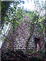
Huddleston Grange tower mill, North Yorkshire
Image: © Bob Paterson
Taken: 29 Aug 2006
0.07 miles
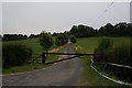
3
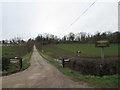
Access Lane to the Yorkshire Equestrian Centre
Heads south off Laith Staid Lane
Image: © Chris Heaton
Taken: 11 Jul 2020
0.16 miles
6
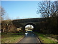
Bridge #CFM-7 Laith Staid Lane, Church Fenton
Image: © Ian S
Taken: 12 Feb 2011
0.20 miles
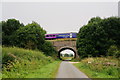
8
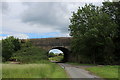
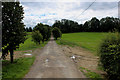
Railway Bridge Spanning Laith Staid Lane
Carries the Leeds/York railway across Laith Staid Lane
Image: © Chris Heaton
Taken: 11 Jul 2020
0.21 miles
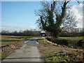
9
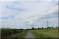
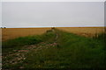
Laith Staid Lane
No Through Road from Sherburn in Elmet that terminates at Huddleston Hall
Image: © Chris Heaton
Taken: 11 Jul 2020
0.21 miles