IMAGES TAKEN NEAR TO
Bishopdyke Road, LEEDS, LS25 6HN
Introduction
This page details the photographs taken nearby to Bishopdyke Road, LS25 6HN by members of the Geograph project.
The Geograph project started in 2005 with the aim of publishing, organising and preserving representative images for every square kilometre of Great Britain, Ireland and the Isle of Man.

There are currently over 7.5m images from over14,400 individuals and you can help contribute to the project by visiting https://www.geograph.org.uk
Image Map
Images are licensed for reuse under creativecommons.org/licenses/by-sa/2.0
Notes
- Clicking on the map will re-center to the selected point.
- The higher the marker number, the further away the image location is from the centre of the postcode.
Image Listing (22 Images Found)
Images are licensed for reuse under creativecommons.org/licenses/by-sa/2.0
Image
Details
Distance
1
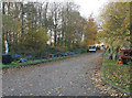
Farm Implements on the road to Keepers Cottage
Image: © Bill Henderson
Taken: 20 Nov 2006
0.07 miles
2
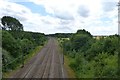
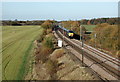
ECML at Bishop Wood
The East Coast Main Line next to Bishops Wood.
Image: © DS Pugh
Taken: 3 Aug 2013
0.07 miles
4
Track beside the railway
The signs relate to access to the line for electrification upgrades.
Image: © DS Pugh
Taken: 2 Jan 2022
0.07 miles
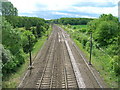
6
East Coast Main Line near Bishop Wood
In this view north from a bridge the East Coast Main Line runs through farmland which is typical of this grid square, in distance is the bridge carrying the B1222 over the railway, which is in Image Over to the east (right) is Bishop Wood.
Image: © Timothy Baldwin
Taken: 20 Jul 2005
0.12 miles
7
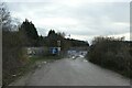
Railway bridge
The road rises to cross the ECML railway line.
Image: © DS Pugh
Taken: 3 Aug 2013
0.13 miles
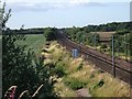
8
Rest Park, Sherburn in Elmet
Looking north along the Doncaster to York section of the East Coast Main-Line from the Bishop Wood bridge, at the eastern end of Sherburn in Elmet Parish. Bishop Wood is on the right and the farms in Biggin village on the horizon to the left.
Image: © Paul Glazzard
Taken: 6 Nov 2007
0.13 miles
9
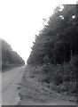
Bishop Wood
The road through Bishop Wood, also referred to as Selby Forest.
Image: © Gerald England
Taken: 12 Jul 1969
0.14 miles