IMAGES TAKEN NEAR TO
Speckled Wood Mews, LS25 6GU
Introduction
This page details the photographs taken nearby to Speckled Wood Mews, LS25 6GU by members of the Geograph project.
The Geograph project started in 2005 with the aim of publishing, organising and preserving representative images for every square kilometre of Great Britain, Ireland and the Isle of Man.

There are currently over 7.5m images from over14,400 individuals and you can help contribute to the project by visiting https://www.geograph.org.uk
Image Map (Loading...)


Getting Data...Please wait
Leaflet Map data © OpenStreetMap
Images are licensed for reuse under creativecommons.org/licenses/by-sa/2.0
Notes
- Clicking on the map will re-center to the selected point.
- The higher the marker number, the further away the image location is from the centre of the postcode.
Image Listing (11 Images Found)
Images are licensed for reuse under creativecommons.org/licenses/by-sa/2.0
Image
Details
Distance

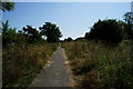
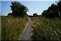
5
Path leading to Pinfold Garth, Sherburn in Elmet
Image: © Ian S
Taken: 23 Jul 2014
0.17 miles
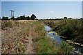
9
Field and railway
Looking towards the Normanton-York lines north of Sherburn in Elmet station.
Image: © DS Pugh
Taken: 13 Jun 2021
0.24 miles
10
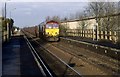
Passing train
Coal train heads south through the station.
Image: © roger geach
Taken: 14 Dec 2001
0.25 miles