IMAGES TAKEN NEAR TO
Church Hill Rise, LEEDS, LS25 6FH
Introduction
This page details the photographs taken nearby to Church Hill Rise, LS25 6FH by members of the Geograph project.
The Geograph project started in 2005 with the aim of publishing, organising and preserving representative images for every square kilometre of Great Britain, Ireland and the Isle of Man.

There are currently over 7.5m images from over14,400 individuals and you can help contribute to the project by visiting https://www.geograph.org.uk
Image Map
Images are licensed for reuse under creativecommons.org/licenses/by-sa/2.0
Notes
- Clicking on the map will re-center to the selected point.
- The higher the marker number, the further away the image location is from the centre of the postcode.
Image Listing (59 Images Found)
Images are licensed for reuse under creativecommons.org/licenses/by-sa/2.0
Image
Details
Distance
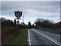
2
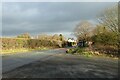
Church Hill
Looking towards the limits of Sherburn from a lay-by.
Image: © DS Pugh
Taken: 9 Jan 2022
0.06 miles
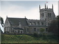
3
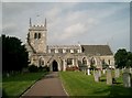
All Saints' Church, Sherburn in Elmet
The parish church of Sherburn in Elmet.
Image: © John Davidson
Taken: 3 Sep 2005
0.09 miles
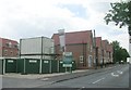
4
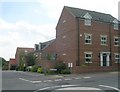
Church Meadow - Church Hill
New housing development.
Image: © Betty Longbottom
Taken: 16 Jun 2009
0.10 miles
6
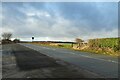
Lay-by beside Church Hill
Looking across part of the layby on the western edge of Sherburn.
Image: © DS Pugh
Taken: 9 Jan 2022
0.10 miles
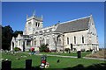
7
All Saints Church from Coldhill Lane, Sherburn in Elmet
Image: © Bill Henderson
Taken: 30 Sep 2006
0.11 miles
9
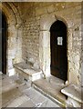
Church of All Saints, Sherburn in Elmet
Door from the porch into the side chapel.
Image: © Alan Murray-Rust
Taken: 20 Dec 2024
0.11 miles
10
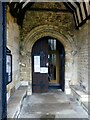
Church of All Saints, Sherburn in Elmet
Norman south door from the original building period, re-sited when the aisle was widened.
Image: © Alan Murray-Rust
Taken: 20 Dec 2024
0.11 miles