IMAGES TAKEN NEAR TO
Fenton Lane, LEEDS, LS25 6EZ
Introduction
This page details the photographs taken nearby to Fenton Lane, LS25 6EZ by members of the Geograph project.
The Geograph project started in 2005 with the aim of publishing, organising and preserving representative images for every square kilometre of Great Britain, Ireland and the Isle of Man.

There are currently over 7.5m images from over14,400 individuals and you can help contribute to the project by visiting https://www.geograph.org.uk
Image Map
Images are licensed for reuse under creativecommons.org/licenses/by-sa/2.0
Notes
- Clicking on the map will re-center to the selected point.
- The higher the marker number, the further away the image location is from the centre of the postcode.
Image Listing (23 Images Found)
Images are licensed for reuse under creativecommons.org/licenses/by-sa/2.0
Image
Details
Distance
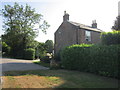
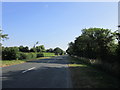
4
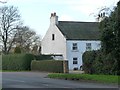
Sherburn Lodge
On the west side of Fenton Lane, east of Sherburn Common.
Image: © Christine Johnstone
Taken: 28 Jan 2016
0.05 miles
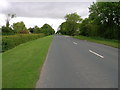
5
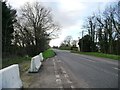
Fenton Lane, between two 8 metre spot heights
Looking south from a blocked works entrance, towards Sherburn Lodge.
Image: © Christine Johnstone
Taken: 28 Jan 2016
0.07 miles
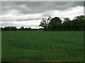
6
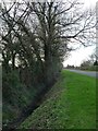
Drain on the east side of Fenton Lane
The flat low land around Church Fenton and Little Fenton floods easily and requires many drains.
Image: © Christine Johnstone
Taken: 28 Jan 2016
0.07 miles
7
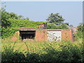
A farm building off Fenton Lane, south of Sherburn Lodge
Image: © Ian S
Taken: 20 Jul 2013
0.09 miles
8
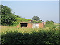
A farm building off Fenton Lane, south of Sherburn Lodge
Image: © Ian S
Taken: 20 Jul 2013
0.09 miles
9
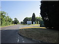
The entrance to British Gypsum Sherburn Works
Image: © Ian S
Taken: 20 Jul 2013
0.12 miles