IMAGES TAKEN NEAR TO
Finkle Hill, LEEDS, LS25 6EA
Introduction
This page details the photographs taken nearby to Finkle Hill, LS25 6EA by members of the Geograph project.
The Geograph project started in 2005 with the aim of publishing, organising and preserving representative images for every square kilometre of Great Britain, Ireland and the Isle of Man.

There are currently over 7.5m images from over14,400 individuals and you can help contribute to the project by visiting https://www.geograph.org.uk
Image Map (Loading...)


Getting Data...Please wait
Leaflet Map data © OpenStreetMap
Images are licensed for reuse under creativecommons.org/licenses/by-sa/2.0
Notes
- Clicking on the map will re-center to the selected point.
- The higher the marker number, the further away the image location is from the centre of the postcode.
Image Listing (114 Images Found)
Images are licensed for reuse under creativecommons.org/licenses/by-sa/2.0
Image
Details
Distance
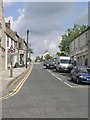
2
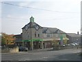
The co-operative food - Finkle Hill
Image: © Betty Longbottom
Taken: 24 Oct 2011
0.03 miles
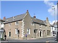
3
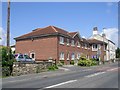
Hilltop Manor Care Home - Finkle Street
Image: © Betty Longbottom
Taken: 16 Jun 2009
0.04 miles
4
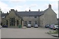
The Old Hungate Hospital - Kirkgate
Now a medical practice.
Image: © Betty Longbottom
Taken: 16 Jun 2009
0.05 miles
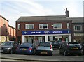
7
Sherburn Library - off Finkle Street
Image: © Betty Longbottom
Taken: 16 Jun 2009
0.06 miles
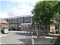
8
The Old Hungate Hospital - Finkle Street
Now a medical practice.
Image: © Betty Longbottom
Taken: 16 Jun 2009
0.06 miles
9
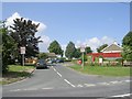
Beech Grove - looking towards Finkle Hill
Image: © Betty Longbottom
Taken: 24 Oct 2011
0.07 miles
10
Gas Installation - off Finkle Hill
Image: © Betty Longbottom
Taken: 24 Oct 2011
0.08 miles