IMAGES TAKEN NEAR TO
Moor Lane, LEEDS, LS25 6DU
Introduction
This page details the photographs taken nearby to Moor Lane, LS25 6DU by members of the Geograph project.
The Geograph project started in 2005 with the aim of publishing, organising and preserving representative images for every square kilometre of Great Britain, Ireland and the Isle of Man.

There are currently over 7.5m images from over14,400 individuals and you can help contribute to the project by visiting https://www.geograph.org.uk
Image Map
Images are licensed for reuse under creativecommons.org/licenses/by-sa/2.0
Notes
- Clicking on the map will re-center to the selected point.
- The higher the marker number, the further away the image location is from the centre of the postcode.
Image Listing (52 Images Found)
Images are licensed for reuse under creativecommons.org/licenses/by-sa/2.0
Image
Details
Distance
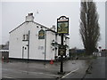
3
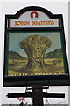
The Wheatsheaf on Moor Lane
http://www.geograph.org.uk/photo/4092384
Image: © Ian S
Taken: 23 Jul 2014
0.03 miles
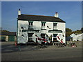
5
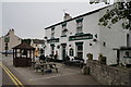
The Wheatsheaf on Moor Lane
http://www.geograph.org.uk/photo/4092391
Image: © Ian S
Taken: 23 Jul 2014
0.04 miles
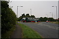
7
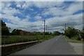
Moor Lane
Looking along Moor Lane from next to the A162.
Image: © DS Pugh
Taken: 13 Jun 2021
0.05 miles
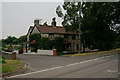
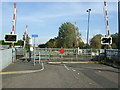
8
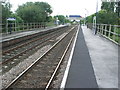
Sherburn-in-Elmet railway station, Yorkshire
Opened in 1840 by the York & North Midland Railway on its line from York towards Castleford, the station closed in 1965 and then reopened in 1984. View south towards Castleford.
Image: © Nigel Thompson
Taken: 15 Aug 2008
0.05 miles