IMAGES TAKEN NEAR TO
North Drive, LEEDS, LS25 6BZ
Introduction
This page details the photographs taken nearby to North Drive, LS25 6BZ by members of the Geograph project.
The Geograph project started in 2005 with the aim of publishing, organising and preserving representative images for every square kilometre of Great Britain, Ireland and the Isle of Man.

There are currently over 7.5m images from over14,400 individuals and you can help contribute to the project by visiting https://www.geograph.org.uk
Image Map
Images are licensed for reuse under creativecommons.org/licenses/by-sa/2.0
Notes
- Clicking on the map will re-center to the selected point.
- The higher the marker number, the further away the image location is from the centre of the postcode.
Image Listing (46 Images Found)
Images are licensed for reuse under creativecommons.org/licenses/by-sa/2.0
Image
Details
Distance
4
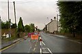
Roadworks Finkle Hill
Outside the Police Station Sherburn in Elmet.
Image: © Steve Fareham
Taken: 9 Sep 2008
0.13 miles
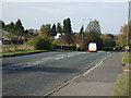
10
A162
Looking over to Shirburn in Elmet.
Image: © Andy Farrington
Taken: 5 Apr 2012
0.16 miles