IMAGES TAKEN NEAR TO
Kirkgate, LEEDS, LS25 6BL
Introduction
This page details the photographs taken nearby to Kirkgate, LS25 6BL by members of the Geograph project.
The Geograph project started in 2005 with the aim of publishing, organising and preserving representative images for every square kilometre of Great Britain, Ireland and the Isle of Man.

There are currently over 7.5m images from over14,400 individuals and you can help contribute to the project by visiting https://www.geograph.org.uk
Image Map (Loading...)


Getting Data...Please wait
Leaflet Map data © OpenStreetMap
Images are licensed for reuse under creativecommons.org/licenses/by-sa/2.0
Notes
- Clicking on the map will re-center to the selected point.
- The higher the marker number, the further away the image location is from the centre of the postcode.
Image Listing (149 Images Found)
Images are licensed for reuse under creativecommons.org/licenses/by-sa/2.0
Image
Details
Distance
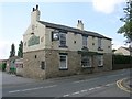
6
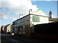
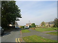
The Foresters Arms, Kirkgate, Sherburn in Elmet
Image: © Ian S
Taken: 12 Feb 2011
0.04 miles
8
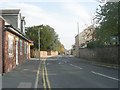
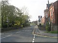
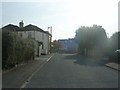
Kirkgate in Sherburn in Elmet
Looking eastward.
Image: © Peter Wood
Taken: 4 Aug 2014
0.06 miles
9
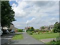
Rudstone Grove - looking towards Kirkgate
Image: © Betty Longbottom
Taken: 24 Oct 2011
0.06 miles
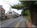
10
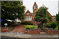
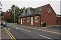
Former School on Kirkgate, Sherburn in Elmet
Now Council Offices.
Image: © Ian S
Taken: 23 Jul 2014
0.07 miles