IMAGES TAKEN NEAR TO
West View, LEEDS, LS25 6AN
Introduction
This page details the photographs taken nearby to West View, LS25 6AN by members of the Geograph project.
The Geograph project started in 2005 with the aim of publishing, organising and preserving representative images for every square kilometre of Great Britain, Ireland and the Isle of Man.

There are currently over 7.5m images from over14,400 individuals and you can help contribute to the project by visiting https://www.geograph.org.uk
Image Map (Loading...)


Getting Data...Please wait
Leaflet Map data © OpenStreetMap
Images are licensed for reuse under creativecommons.org/licenses/by-sa/2.0
Notes
- Clicking on the map will re-center to the selected point.
- The higher the marker number, the further away the image location is from the centre of the postcode.
Image Listing (16 Images Found)
Images are licensed for reuse under creativecommons.org/licenses/by-sa/2.0
Image
Details
Distance
1
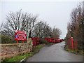
Entrance to scrapyard, New Lane
This is also a public bridleway.
Image: © Christine Johnstone
Taken: 20 Dec 2011
0.11 miles
2
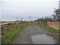
New Lane
Where it changes from a road to a track [and also a bridleway].
Image: © Christine Johnstone
Taken: 20 Dec 2011
0.12 miles
3
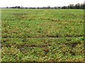
Winter cereals on the edge of Sherburn in Elmet
South of New Lane.
Image: © Christine Johnstone
Taken: 20 Dec 2011
0.13 miles
4
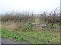
A sledgehammer to crack a nut?
Closing a gap in New Lane's hedge.
Image: © Christine Johnstone
Taken: 20 Dec 2011
0.13 miles
5
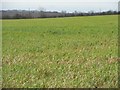
Cereal crop south of New Lane
The field drops down to the Mill Dike valley.
Image: © Christine Johnstone
Taken: 20 Dec 2011
0.15 miles