IMAGES TAKEN NEAR TO
Betteras Hill Road, LEEDS, LS25 5PF
Introduction
This page details the photographs taken nearby to Betteras Hill Road, LS25 5PF by members of the Geograph project.
The Geograph project started in 2005 with the aim of publishing, organising and preserving representative images for every square kilometre of Great Britain, Ireland and the Isle of Man.

There are currently over 7.5m images from over14,400 individuals and you can help contribute to the project by visiting https://www.geograph.org.uk
Image Map (Loading...)


Getting Data...Please wait
Leaflet Map data © OpenStreetMap
Images are licensed for reuse under creativecommons.org/licenses/by-sa/2.0
Notes
- Clicking on the map will re-center to the selected point.
- The higher the marker number, the further away the image location is from the centre of the postcode.
Image Listing (4 Images Found)
Images are licensed for reuse under creativecommons.org/licenses/by-sa/2.0
Image
Details
Distance
1
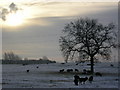
Monk Fryston Lodge Farm
Taken from SE489296 looking SSW. Part of the National Grid substation at SE483292 can be seen on the right. It's not just the light, that is a whole flock of black sheep.
Image: © Roger W Haworth
Taken: 29 Dec 2005
0.14 miles
2
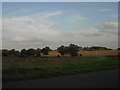
View to Monk Fryston Lodge
View from the road to Lumby across fields and the A63 to Monk Fryston Lodge.
Image: © Darren Haddock
Taken: 20 Sep 2006
0.15 miles
3
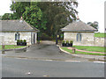
Gate Houses, Monk Fryston Lodge, Monk Fryston.
This entrance is on the west side of the A162, approximately 50 yards south of the junction with the A63.
Image: © Bill Henderson
Taken: 19 Sep 2006
0.25 miles