IMAGES TAKEN NEAR TO
Hillam Hall View, LEEDS, LS25 5NR
Introduction
This page details the photographs taken nearby to Hillam Hall View, LS25 5NR by members of the Geograph project.
The Geograph project started in 2005 with the aim of publishing, organising and preserving representative images for every square kilometre of Great Britain, Ireland and the Isle of Man.

There are currently over 7.5m images from over14,400 individuals and you can help contribute to the project by visiting https://www.geograph.org.uk
Image Map
Images are licensed for reuse under creativecommons.org/licenses/by-sa/2.0
Notes
- Clicking on the map will re-center to the selected point.
- The higher the marker number, the further away the image location is from the centre of the postcode.
Image Listing (48 Images Found)
Images are licensed for reuse under creativecommons.org/licenses/by-sa/2.0
Image
Details
Distance
1
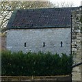
Stable block, Hall Farm, Hillam
Probably early 17th century, stable with hayloft over, now converted to residential use, Listed Grade II. The north side, facing the original farmyard.
Image: © Alan Murray-Rust
Taken: 9 Dec 2019
0.02 miles
2
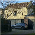
Stable block, Hall Farm, Hillam
Probably early 17th century, stable with hayloft over, now converted to residential use, Listed Grade II. The south side.
Image: © Alan Murray-Rust
Taken: 9 Dec 2019
0.02 miles
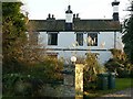
3
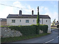
Burton Cottage and Chantries Cottage
Stone built with rendered finish, dating from the 17th century. Listed Grade II.
Image: © Alan Murray-Rust
Taken: 27 Dec 2013
0.03 miles
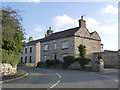
4
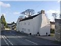
Hall Farmhouse
Probably early 17th century, stone-built with later render. Reputedly the original Hillam Hall. Listed Grade II.
Image: © Alan Murray-Rust
Taken: 27 Dec 2013
0.04 miles
5
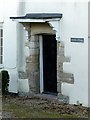
Doorway to Burton Cottage, Hillam
17th century doorway with stone quoin jambs. The building is reputed to have been the earlier Hillam Hall. Listed Grade II.
Image: © Alan Murray-Rust
Taken: 9 Dec 2019
0.05 miles
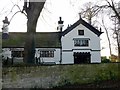
6
Home Farm, Hillam
Traditional Farmhouse in freestone.
Image: © Alan Murray-Rust
Taken: 27 Dec 2013
0.05 miles
7
Hillam Hall, west wing
Built in 1827 in Elizabethan revival style, although the house has earlier origins, Listed Grade II. The plaque above the window carries the date AM 5835 – see http://www.geograph.org.uk/photo/6345499 for an explanation of this date.
Image: © Alan Murray-Rust
Taken: 9 Dec 2019
0.05 miles
8
West House, Hillam Hall
Originally part of the Hillam Hall, now a separate dwelling. Built in 1827 in Elizabethan revival style, Listed Grade II.
Image: © Alan Murray-Rust
Taken: 9 Dec 2019
0.05 miles
9
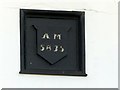
Hillam Hall, datestone, west wing
AM represents Anno Mundi (The year of the world) and refers to the date of the creation of the world derived by Bishop Ussher from the Judaic/Christian scriptures. See Wikipedia https://en.wikipedia.org/wiki/Ussher_chronology for more information on Ussher and http://www.geograph.org.uk/photo/6345400 for location.
Image: © Alan Murray-Rust
Taken: 9 Dec 2019
0.05 miles
10
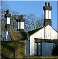
Chimneys at Hillam Hall
Early 19th century Elizabethan revival style, Listed Grade II.
Image: © Alan Murray-Rust
Taken: 9 Dec 2019
0.05 miles