IMAGES TAKEN NEAR TO
Milford Way, LEEDS, LS25 5GJ
Introduction
This page details the photographs taken nearby to Milford Way, LS25 5GJ by members of the Geograph project.
The Geograph project started in 2005 with the aim of publishing, organising and preserving representative images for every square kilometre of Great Britain, Ireland and the Isle of Man.

There are currently over 7.5m images from over14,400 individuals and you can help contribute to the project by visiting https://www.geograph.org.uk
Image Map
Images are licensed for reuse under creativecommons.org/licenses/by-sa/2.0
Notes
- Clicking on the map will re-center to the selected point.
- The higher the marker number, the further away the image location is from the centre of the postcode.
Image Listing (24 Images Found)
Images are licensed for reuse under creativecommons.org/licenses/by-sa/2.0
Image
Details
Distance
1
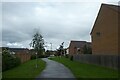
Path to Swan Road
Looking along a path through a new housing estate in South Milford.
Image: © DS Pugh
Taken: 22 Aug 2021
0.11 miles
2
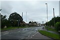
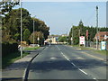
Zebra Crossing on Low Street
Located between Harvester Way and Beech Drive.
Image: © DS Pugh
Taken: 22 Aug 2021
0.11 miles
3
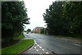
Low Street
Looking along Low Street from Harvester Way.
Image: © DS Pugh
Taken: 22 Aug 2021
0.11 miles
10
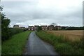
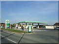
Path to South Milford
At one point this was a road meeting the A162, now the junction has been removed.
Image: © DS Pugh
Taken: 22 Aug 2021
0.17 miles