IMAGES TAKEN NEAR TO
Imperial Gardens, LEEDS, LS25 5FR
Introduction
This page details the photographs taken nearby to Imperial Gardens, LS25 5FR by members of the Geograph project.
The Geograph project started in 2005 with the aim of publishing, organising and preserving representative images for every square kilometre of Great Britain, Ireland and the Isle of Man.

There are currently over 7.5m images from over14,400 individuals and you can help contribute to the project by visiting https://www.geograph.org.uk
Image Map
Images are licensed for reuse under creativecommons.org/licenses/by-sa/2.0
Notes
- Clicking on the map will re-center to the selected point.
- The higher the marker number, the further away the image location is from the centre of the postcode.
Image Listing (27 Images Found)
Images are licensed for reuse under creativecommons.org/licenses/by-sa/2.0
Image
Details
Distance
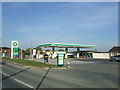
1
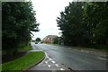
Low Street
Looking along Low Street from Harvester Way.
Image: © DS Pugh
Taken: 22 Aug 2021
0.03 miles
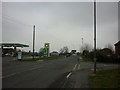
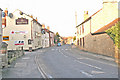
3
Zebra Crossing on Low Street
Located between Harvester Way and Beech Drive.
Image: © DS Pugh
Taken: 22 Aug 2021
0.06 miles
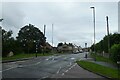
7
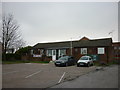
The South Milford British Legion Club
The club sells all type's of beer including Sam Smith's.
Image: © Ian S
Taken: 17 Feb 2011
0.07 miles
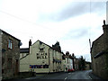
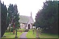
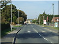
10
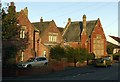
The old school house and school, South Milford
Classic late 19th century school, now entirely converted for residential use.
Image: © Alan Murray-Rust
Taken: 9 Dec 2019
0.19 miles