IMAGES TAKEN NEAR TO
Fryston Common Lane, LEEDS, LS25 5EP
Introduction
This page details the photographs taken nearby to Fryston Common Lane, LS25 5EP by members of the Geograph project.
The Geograph project started in 2005 with the aim of publishing, organising and preserving representative images for every square kilometre of Great Britain, Ireland and the Isle of Man.

There are currently over 7.5m images from over14,400 individuals and you can help contribute to the project by visiting https://www.geograph.org.uk
Image Map (Loading...)


Getting Data...Please wait
Leaflet Map data © OpenStreetMap
Images are licensed for reuse under creativecommons.org/licenses/by-sa/2.0
Notes
- Clicking on the map will re-center to the selected point.
- The higher the marker number, the further away the image location is from the centre of the postcode.
Image Listing (3 Images Found)
Images are licensed for reuse under creativecommons.org/licenses/by-sa/2.0
Image
Details
Distance
2
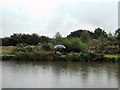
Fryston Grange Fishing Pond
A Rainy day at Fishing ponds at Fryston Grange Farm Monk Fryston.
Image: © derek dye
Taken: 31 Jul 2013
0.19 miles
3
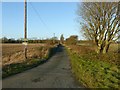
The lane to Fryston Grange
Mapped as a byway. Fryston Grange is shown as Common Farm on the 1850s 6-inch map, but had been renamed by the end of the century.
Image: © Alan Murray-Rust
Taken: 9 Dec 2019
0.22 miles