IMAGES TAKEN NEAR TO
Common Lane, LEEDS, LS25 5DW
Introduction
This page details the photographs taken nearby to Common Lane, LS25 5DW by members of the Geograph project.
The Geograph project started in 2005 with the aim of publishing, organising and preserving representative images for every square kilometre of Great Britain, Ireland and the Isle of Man.

There are currently over 7.5m images from over14,400 individuals and you can help contribute to the project by visiting https://www.geograph.org.uk
Image Map (Loading...)


Getting Data...Please wait
Leaflet Map data © OpenStreetMap
Images are licensed for reuse under creativecommons.org/licenses/by-sa/2.0
Notes
- Clicking on the map will re-center to the selected point.
- The higher the marker number, the further away the image location is from the centre of the postcode.
Image Listing (16 Images Found)
Images are licensed for reuse under creativecommons.org/licenses/by-sa/2.0
Image
Details
Distance
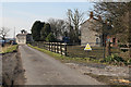
3
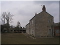
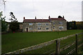
Passing Milford Lodge
Looking along Common Lane.
Image: © DS Pugh
Taken: 22 Aug 2021
0.01 miles
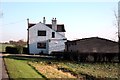
6
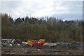
Along Common Lane
Common Lane runs along the south of Gascoigne Wood.
Image: © DS Pugh
Taken: 22 Aug 2021
0.15 miles
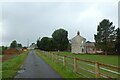
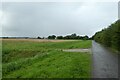
7
Common Lane west of Milford Lodge
Looking along the road leading towards South Milford.
Image: © DS Pugh
Taken: 22 Aug 2021
0.17 miles
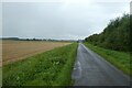
9
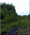
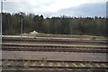
Gascoigne Wood Mine disused sidings
Where once millions of tons of Selby coal from the "Jewel in the Crown" of the British Coal mining industry flowed. Now only weeds and trees grow between the rails.
Image: © derek dye
Taken: 11 Jul 2011
0.19 miles