IMAGES TAKEN NEAR TO
Common Lane, LEEDS, LS25 5DL
Introduction
This page details the photographs taken nearby to Common Lane, LS25 5DL by members of the Geograph project.
The Geograph project started in 2005 with the aim of publishing, organising and preserving representative images for every square kilometre of Great Britain, Ireland and the Isle of Man.

There are currently over 7.5m images from over14,400 individuals and you can help contribute to the project by visiting https://www.geograph.org.uk
Image Map
Images are licensed for reuse under creativecommons.org/licenses/by-sa/2.0
Notes
- Clicking on the map will re-center to the selected point.
- The higher the marker number, the further away the image location is from the centre of the postcode.
Image Listing (13 Images Found)
Images are licensed for reuse under creativecommons.org/licenses/by-sa/2.0
Image
Details
Distance
1
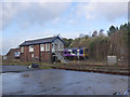
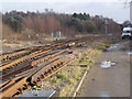
Gascoigne Wood Signal Box
A large box of North Eastern Railway origin (built 1908) controlling a 3-way junction. Originally a traditional manually operated box, an electronic panel was installed around the time of the development of Gascoigne Wood Mine. The Leeds to Hull line has connecting curves north and south onto the York to Sheffield line. A Northern Trains Hull to York services passes behind.
Image: © Alan Murray-Rust
Taken: 27 Dec 2013
0.01 miles
4
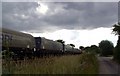
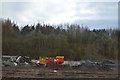
Coal train passing Gascoigne Wood
An ironic sight! The dark clouds gather as a train, probably carrying foreign coal, passes the now closed and derelict Gascoigne Wood mine, where tens of millions of tons of coal from the five Selby Coalfield mines came to the surface. The "enemy within" were right!
Image: © derek dye
Taken: 11 Jul 2011
0.12 miles
7
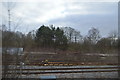
Gascoigne Wood Junction
In the foreground is the curve off the Sheffield to York line from Monk Fryston Junction.
Image: © Alan Murray-Rust
Taken: 27 Dec 2013
0.16 miles
8
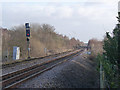
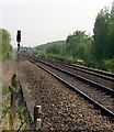
The approach to Gascoigne Wood Junction
The two aspect colour light signal is the equivalent of the traditional mechanical stop signal. The screen above is known as a 'theatre' indicator and would inform the driver which track he was being routed onto. Below is a 'calling on' signal which would allow a driver to pass the main signal at red to pull forward at slow speed for a shunting manoeuvre.
Image: © Alan Murray-Rust
Taken: 27 Dec 2013
0.18 miles
10
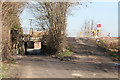
Railway bridge and manual level crossing
Norden's Barn Farm is just beyond the bridge.
Image: © Andrew Whale
Taken: 28 Feb 2013
0.22 miles