IMAGES TAKEN NEAR TO
LS25 1FL
Introduction
This page details the photographs taken nearby to LS25 1FL by members of the Geograph project.
The Geograph project started in 2005 with the aim of publishing, organising and preserving representative images for every square kilometre of Great Britain, Ireland and the Isle of Man.

There are currently over 7.5m images from over14,400 individuals and you can help contribute to the project by visiting https://www.geograph.org.uk
Image Map (Loading...)


Getting Data...Please wait
Leaflet Map data © OpenStreetMap
Images are licensed for reuse under creativecommons.org/licenses/by-sa/2.0
Notes
- Clicking on the map will re-center to the selected point.
- The higher the marker number, the further away the image location is from the centre of the postcode.
Image Listing (47 Images Found)
Images are licensed for reuse under creativecommons.org/licenses/by-sa/2.0
Image
Details
Distance
1
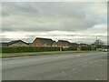
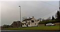
Houses on Selby Road, West Garforth
These are fairly modern houses but a larger new development was being built behind them.
Image: © Stephen Craven
Taken: 22 Jan 2022
0.04 miles
2
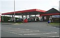
Total Filling Station - Selby Road
Image: © Betty Longbottom
Taken: 19 Mar 2008
0.04 miles
3
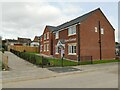
Show and View Homes for Silverwood
The entrance to a housing development currently under construction in Garforth. I don't know the distinction between a show home and a view home - maybe one is furnished and the other not?
Image: © Stephen Craven
Taken: 19 Mar 2023
0.05 miles
4
Silverwood estate
A housing development currently under construction in Garforth.
Image: © Stephen Craven
Taken: 19 Mar 2023
0.05 miles
6
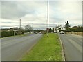
Selby Road, West Garforth
This view shows the old and new road alignments; the old route now provides convenient parking for the pub.
Image: © Stephen Craven
Taken: 22 Jan 2022
0.06 miles
7
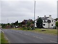
Selby Road, Garforth
Passing the Gaping Goose.
Image: © Richard Webb
Taken: 30 May 2023
0.07 miles
8
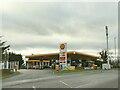
Shell filling station, Selby Road, West Garforth
As of January 2022, diesel was 149.9 p/l, E10 petrol 144.9 p/l. This was a Total branded station in 2012 Image
Image: © Stephen Craven
Taken: 22 Jan 2022
0.08 miles
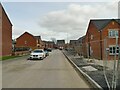
9
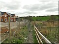
Footpath alongside the Silverwood estate
A pre-existing public footpath, now rather muddy even in otherwise dry conditions.
Image: © Stephen Craven
Taken: 19 Mar 2023
0.08 miles
10
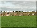
The new Silverwood estate
Viewed from a public footpath to the south.
Image: © Stephen Craven
Taken: 19 Mar 2023
0.08 miles