IMAGES TAKEN NEAR TO
Hallgarth Close, TADCASTER, LS24 9TW
Introduction
This page details the photographs taken nearby to Hallgarth Close, LS24 9TW by members of the Geograph project.
The Geograph project started in 2005 with the aim of publishing, organising and preserving representative images for every square kilometre of Great Britain, Ireland and the Isle of Man.

There are currently over 7.5m images from over14,400 individuals and you can help contribute to the project by visiting https://www.geograph.org.uk
Image Map (Loading...)


Getting Data...Please wait
Leaflet Map data © OpenStreetMap
Images are licensed for reuse under creativecommons.org/licenses/by-sa/2.0
Notes
- Clicking on the map will re-center to the selected point.
- The higher the marker number, the further away the image location is from the centre of the postcode.
Image Listing (40 Images Found)
Images are licensed for reuse under creativecommons.org/licenses/by-sa/2.0
Image
Details
Distance
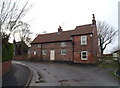
3

Bell Lane
Entering Ulleskelf along Bell Lane as it meets Main Street and Ings Road.
Image: © DS Pugh
Taken: 30 Apr 2017
0.05 miles
5

Along Main Street
Looking along Main Street in Ulleskelf.
Image: © DS Pugh
Taken: 30 Apr 2017
0.07 miles
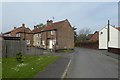
8
On Main Street, Ulleskelf
Main Street weaves a serpentine course through the village of Ulleskelf
Image: © Chris Heaton
Taken: 24 Oct 2018
0.10 miles
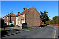
9
Houses on Main Street
Looking along part of Main Street in Ulleskelf.
Image: © DS Pugh
Taken: 30 Apr 2017
0.10 miles
10
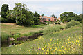
Houses in Ulleskelf and the site of the old ferry crossing
Houses on Ings Road, Ulleskelf viewed from the other side of the River Wharfe. These houses are built on the site of the old Ship Inn from where the ferry used to operate in the early 1900's. The exact location of the ferry crossing can be identified where the footpaths converge on the north and south sides of the river.
Image: © Andrew Whale
Taken: 25 Jun 2010
0.11 miles