IMAGES TAKEN NEAR TO
The Links, TADCASTER, LS24 9SY
Introduction
This page details the photographs taken nearby to The Links, LS24 9SY by members of the Geograph project.
The Geograph project started in 2005 with the aim of publishing, organising and preserving representative images for every square kilometre of Great Britain, Ireland and the Isle of Man.

There are currently over 7.5m images from over14,400 individuals and you can help contribute to the project by visiting https://www.geograph.org.uk
Image Map
Images are licensed for reuse under creativecommons.org/licenses/by-sa/2.0
Notes
- Clicking on the map will re-center to the selected point.
- The higher the marker number, the further away the image location is from the centre of the postcode.
Image Listing (58 Images Found)
Images are licensed for reuse under creativecommons.org/licenses/by-sa/2.0
Image
Details
Distance
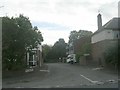
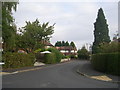
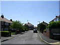
2
Stutton Road near Golf Links Court
Looking along Stutton Road in Tadcaster.
Image: © DS Pugh
Taken: 5 Jun 2021
0.04 miles

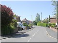
6
Golf Links Crescent - Golf Links Avenue
Image: © Betty Longbottom
Taken: 24 Sep 2011
0.08 miles
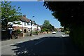
8
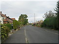
Golf Links Avenue - viewed from Golf Links Crescent
Image: © Betty Longbottom
Taken: 24 Sep 2011
0.10 miles
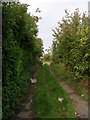
9
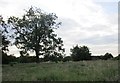
Grass field on the outskirts of Tadcater
Image: © Jonathan Thacker
Taken: 8 Jun 2018
0.10 miles
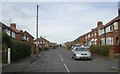
10
Calcaria Road - Calcaria Crescent
Image: © Betty Longbottom
Taken: 11 May 2009
0.11 miles