IMAGES TAKEN NEAR TO
Little Ings Close, TADCASTER, LS24 9RZ
Introduction
This page details the photographs taken nearby to Little Ings Close, LS24 9RZ by members of the Geograph project.
The Geograph project started in 2005 with the aim of publishing, organising and preserving representative images for every square kilometre of Great Britain, Ireland and the Isle of Man.

There are currently over 7.5m images from over14,400 individuals and you can help contribute to the project by visiting https://www.geograph.org.uk
Image Map (Loading...)


Getting Data...Please wait
Leaflet Map data © OpenStreetMap
Images are licensed for reuse under creativecommons.org/licenses/by-sa/2.0
Notes
- Clicking on the map will re-center to the selected point.
- The higher the marker number, the further away the image location is from the centre of the postcode.
Image Listing (22 Images Found)
Images are licensed for reuse under creativecommons.org/licenses/by-sa/2.0
Image
Details
Distance
1
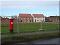
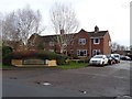
New houses, Church Fenton
Showing position of Postbox No. LS24 824.
See Image] for postbox.
Image: © JThomas
Taken: 8 Feb 2020
0.07 miles
2
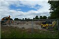
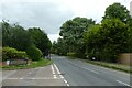
Construction along Busk Lane
Looking across a construction site along Busk Lane near Leeds East Airport.
Image: © DS Pugh
Taken: 13 Jun 2021
0.09 miles
3
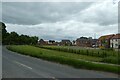
Houses beside Busk Lane
Looking along Busk Lane near Leeds East Airport.
Image: © DS Pugh
Taken: 13 Jun 2021
0.10 miles
4
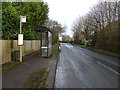
Bus stop and shelter on Busk Lane, Church Fenton
Image: © JThomas
Taken: 8 Feb 2020
0.10 miles
5
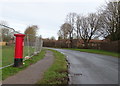
Busk Lane, Church Fenton
Showing position of Postbox No. LS24 824.
See Image] for postbox.
Image: © JThomas
Taken: 8 Feb 2020
0.10 miles
6
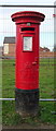
George V postbox on Busk Lane, Church Fenton
Image: © JThomas
Taken: 8 Feb 2020
0.11 miles
7
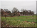
Former RAF Houses, Church Fenton, North Yorkshire
Church Fenton village is dominated by the airfield and RAF base, with a significant amount of post-war housing provided by the Ministry of Defence. Gradually it lost its operational status and is now home to the Yorkshire Universities Air Squadron. See the following extract from Wikipedia:
"From 1998-2003 Church Fenton was the RAF's main Elementary Flying Training airfield. The base is still home to Yorkshire Universities Air Squadron and it is from there that they conduct their flying training in the Grob Tutor Aircraft. Much of the base is now derelict and fenced off and the Officers Mess has been demolished. The airside section of the base remains open with various hangars incorporating YUAS’s aircraft, engineering support, fire/ambulance facilities and a sports hangar. The base still has a fully functioning and manned Air Traffic Control Tower. The Station headquarters remains and incorporates YUAS’s administration, presentation and social facilities. There is a canteen facility known as the "feeder" and a basic accommodation block."
Image: © Robert Neilson
Taken: 16 Jan 2007
0.11 miles
9
Junction with Dorts Crescent
Looking along Busk Lane towards Church Fenton.
Image: © DS Pugh
Taken: 13 Jun 2021
0.13 miles
10
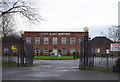
Leeds East Airport
The former RAF Church Fenton.
Image: © JThomas
Taken: 8 Feb 2020
0.13 miles