IMAGES TAKEN NEAR TO
Saxton, TADCASTER, LS24 9QJ
Introduction
This page details the photographs taken nearby to LS24 9QJ by members of the Geograph project.
The Geograph project started in 2005 with the aim of publishing, organising and preserving representative images for every square kilometre of Great Britain, Ireland and the Isle of Man.

There are currently over 7.5m images from over14,400 individuals and you can help contribute to the project by visiting https://www.geograph.org.uk
Image Map
Images are licensed for reuse under creativecommons.org/licenses/by-sa/2.0
Notes
- Clicking on the map will re-center to the selected point.
- The higher the marker number, the further away the image location is from the centre of the postcode.
Image Listing (24 Images Found)
Images are licensed for reuse under creativecommons.org/licenses/by-sa/2.0
Image
Details
Distance
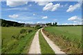
1
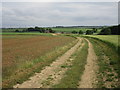
Bridleway to Newstead Farm
Newstead Farm stands in a shallow valley drained by a tributary of the Cock Beck.
Image: © Jonathan Thacker
Taken: 8 Jun 2018
0.01 miles
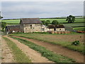
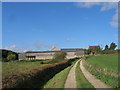
3
Newstead Farm from the north
The farm has a mixture of very old and very modern buildings
Image: © John Slater
Taken: 1 Oct 2012
0.01 miles
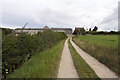
5
Newstead Farm
The path is a bridleway from Saxton to Tadcaster.
Image: © DS Pugh
Taken: 3 Aug 2013
0.02 miles
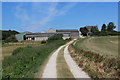
7

Newstead Farm, Yorkshire.
The approach to Newstead Farm from the South.
Image: © Derek Parkinson
Taken: 11 Mar 2007
0.03 miles
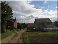
9
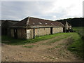
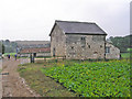
Stone barns and granary, Newstead Farm
Image: © Jonathan Thacker
Taken: 8 Jun 2018
0.03 miles
10
Newstead Farm
Newstead Farm was part of the Hazelwood estate and this is one of its older buildings.
Image: © John Illingworth
Taken: 8 Sep 2010
0.05 miles