IMAGES TAKEN NEAR TO
Kelcbar Close, TADCASTER, LS24 9NY
Introduction
This page details the photographs taken nearby to Kelcbar Close, LS24 9NY by members of the Geograph project.
The Geograph project started in 2005 with the aim of publishing, organising and preserving representative images for every square kilometre of Great Britain, Ireland and the Isle of Man.

There are currently over 7.5m images from over14,400 individuals and you can help contribute to the project by visiting https://www.geograph.org.uk
Image Map (Loading...)


Getting Data...Please wait
Leaflet Map data © OpenStreetMap
Images are licensed for reuse under creativecommons.org/licenses/by-sa/2.0
Notes
- Clicking on the map will re-center to the selected point.
- The higher the marker number, the further away the image location is from the centre of the postcode.
Image Listing (34 Images Found)
Images are licensed for reuse under creativecommons.org/licenses/by-sa/2.0
Image
Details
Distance
6
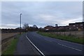
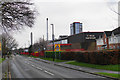
Wetherby Road on the edge of Tadcaster
Looking along the A659 leading into Tadcaster.
Image: © DS Pugh
Taken: 26 Nov 2017
0.08 miles
8
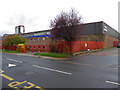
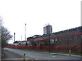
Molson Coors Tower Brewery, Tadcaster
This is a large relatively modern brewery on an old site. i'm glad I walked out to this corner as it is in a different grid square.
Image: © Chris Allen
Taken: 4 Nov 2017
0.10 miles
9
Tower Brewery
One of three breweries currently in the town. This one is owned by Molson Coors having been acquired from Bass, and produces such things as Carling.
Image: © Bill Boaden
Taken: 4 Mar 2017
0.10 miles
10
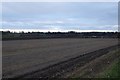
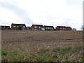
Farmland beside Wetherby Road
Looking across fields north of the A659 near Riverside Community Primary School.
Image: © DS Pugh
Taken: 26 Nov 2017
0.10 miles