IMAGES TAKEN NEAR TO
Heatherdene, TADCASTER, LS24 8EZ
Introduction
This page details the photographs taken nearby to Heatherdene, LS24 8EZ by members of the Geograph project.
The Geograph project started in 2005 with the aim of publishing, organising and preserving representative images for every square kilometre of Great Britain, Ireland and the Isle of Man.

There are currently over 7.5m images from over14,400 individuals and you can help contribute to the project by visiting https://www.geograph.org.uk
Image Map
Images are licensed for reuse under creativecommons.org/licenses/by-sa/2.0
Notes
- Clicking on the map will re-center to the selected point.
- The higher the marker number, the further away the image location is from the centre of the postcode.
Image Listing (232 Images Found)
Images are licensed for reuse under creativecommons.org/licenses/by-sa/2.0
Image
Details
Distance
3
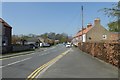
Wighill Lane near Prospect Drive
Looking along Wighill Lane on the northern edge of Tadcaster.
Image: © DS Pugh
Taken: 8 Apr 2017
0.04 miles
7
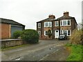
Mill House, Mill Lane, Tadcaster
Presumably built as an administrative office for the corn mill. There had been a mill on this site since medieval times. Ingleby Mill, as it was then known, was rebuilt c.1806 (the remaining house may date from that time) but destroyed in a fire in 1861. It was rebuilt once more, and was served by a railway line across the viaduct from 1888, but milling ceased in 1900, after which the weir and mill buildings were used for a hydro-electric power station until 1955. The other buildings were all demolished by 1982.
Source: https://www.tadhistory.org.uk/history/industries/milling/ingleby-mill
Image: © Stephen Craven
Taken: 1 Apr 2024
0.08 miles
8
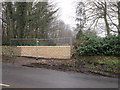
A new wall on Wighill Lane
The former children's home has been bought by Sam Smith's and they are blocking off all access to locals walking the only traffic free route from one end of Tadcaster to the other.
Image: © Ian S
Taken: 3 Mar 2012
0.08 miles