IMAGES TAKEN NEAR TO
Catterton, TADCASTER, LS24 8DL
Introduction
This page details the photographs taken nearby to LS24 8DL by members of the Geograph project.
The Geograph project started in 2005 with the aim of publishing, organising and preserving representative images for every square kilometre of Great Britain, Ireland and the Isle of Man.

There are currently over 7.5m images from over14,400 individuals and you can help contribute to the project by visiting https://www.geograph.org.uk
Image Map
Images are licensed for reuse under creativecommons.org/licenses/by-sa/2.0
Notes
- Clicking on the map will re-center to the selected point.
- The higher the marker number, the further away the image location is from the centre of the postcode.
Image Listing (5 Images Found)
Images are licensed for reuse under creativecommons.org/licenses/by-sa/2.0
Image
Details
Distance
1
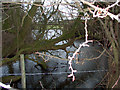
Moat
A view of the Moat by Old Street Farm near Catterton.
Image: © Brian C Payne
Taken: 18 Jan 2007
0.17 miles
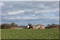
5
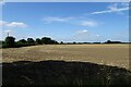
Fields beside Catterton Lane
With a group of Greylag geese in the field.
Image: © DS Pugh
Taken: 3 Aug 2024
0.23 miles