IMAGES TAKEN NEAR TO
Walshford, WETHERBY, LS22 5HX
Introduction
This page details the photographs taken nearby to LS22 5HX by members of the Geograph project.
The Geograph project started in 2005 with the aim of publishing, organising and preserving representative images for every square kilometre of Great Britain, Ireland and the Isle of Man.

There are currently over 7.5m images from over14,400 individuals and you can help contribute to the project by visiting https://www.geograph.org.uk
Image Map (Loading...)


Getting Data...Please wait
Leaflet Map data © OpenStreetMap
Images are licensed for reuse under creativecommons.org/licenses/by-sa/2.0
Notes
- Clicking on the map will re-center to the selected point.
- The higher the marker number, the further away the image location is from the centre of the postcode.
Image Listing (6 Images Found)
Images are licensed for reuse under creativecommons.org/licenses/by-sa/2.0
Image
Details
Distance
1
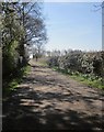
Track to Lund House Farm
Seen from Moor Lane.
Image: © Derek Harper
Taken: 6 Apr 2015
0.14 miles
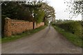
3
Gateway, Moor Lane
The concrete block ensures that not just anybody drives into this field.
Image: © Derek Harper
Taken: 6 Apr 2015
0.21 miles
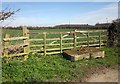
4
Moor Lane
Approaching the roundabout with the A168.
Image: © JThomas
Taken: 7 Dec 2013
0.21 miles
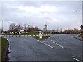
5
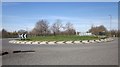
Roundabout, A168
On the east side of the A1(M), but not providing a link to it.
Image: © Derek Harper
Taken: 6 Apr 2015
0.22 miles
6
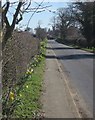
Moor Lane
Heading from the roundabout shown in Image] more or less straight to the village of Hunsingore.
Image: © Derek Harper
Taken: 6 Apr 2015
0.23 miles