IMAGES TAKEN NEAR TO
Trip Lane, WETHERBY, LS22 4JA
Introduction
This page details the photographs taken nearby to Trip Lane, LS22 4JA by members of the Geograph project.
The Geograph project started in 2005 with the aim of publishing, organising and preserving representative images for every square kilometre of Great Britain, Ireland and the Isle of Man.

There are currently over 7.5m images from over14,400 individuals and you can help contribute to the project by visiting https://www.geograph.org.uk
Image Map (Loading...)


Getting Data...Please wait
Leaflet Map data © OpenStreetMap
Images are licensed for reuse under creativecommons.org/licenses/by-sa/2.0
Notes
- Clicking on the map will re-center to the selected point.
- The higher the marker number, the further away the image location is from the centre of the postcode.
Image Listing (14 Images Found)
Images are licensed for reuse under creativecommons.org/licenses/by-sa/2.0
Image
Details
Distance
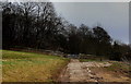
1
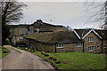
Woodhall Hotel
The back of the hotel buildings
Image: © Chris Heaton
Taken: 13 Mar 2015
0.03 miles
2
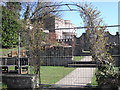
Wood Hall Hotel from its Italian garden
Wood Hall is a small country-house hotel and spa set primarily in a beautiful eighteenth century house surrounded by extensive woods and grounds leading down to the River Wharfe. The Italian garden is fenced off for repair work here, slightly spoiling the view.
Image: © Chris Denny
Taken: 19 Mar 2011
0.04 miles
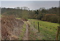
3
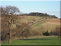
Wood Hall: A view from the terrace
Looking from the terrace of Wood Hall Hotel towards Trip Lane, which links it to the village of Linton.
Image: © Chris Denny
Taken: 18 Mar 2011
0.09 miles
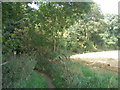
4
Bridge in the woods - an industrial past?
The path between Sicklinghall and Wood Hall crosses a tiny stream as it enters the extensive woodland near the latter. However, between the photography position and the bridge is an area that appears to have been artificially hollowed out and the photography position itself is on an elevated causeway which suggests it may have been some sort of small dam. The bridge is exceptionally wide for what is otherwise a fairly narrow lane and one is led to speculate on some possible long gone industrial activity in this area. The woods behind are called Lime Kiln Wood on the two and a half inch map which may give some indication, but internet trawls reveal nothing.
Image: © Chris Denny
Taken: 19 Mar 2011
0.16 miles
5
Ebor Way approaching Woods
The long distance footpath entering trees that conceals Woodhall Hotel
Image: © Chris Heaton
Taken: 13 Mar 2015
0.18 miles
6
Ebor Way descending from Sicklinghall House
The long distance footpath approaching Old Wives' Wood
Image: © Chris Heaton
Taken: 13 Mar 2015
0.20 miles
8
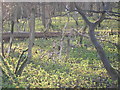
Flowers in Lime Kiln Woods
I am not quite sure what these ones are but nearby there was some wild garlic just coming into shoot and giving off their most distinctive smell. Moral of this is to always carry a wild flower book!
Image: © Chris Denny
Taken: 18 Mar 2011
0.20 miles
9
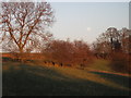
Moon rising
A full moon rising as seen from the lane between Sickinghall and Wood Hall. I later read that for reasons I couldn't quite grasp, this was the evening of the 'largest' moon to be seen this year.
Image: © Chris Denny
Taken: 18 Mar 2011
0.21 miles
10
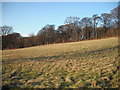
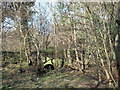
Woodland near Trip Lane
Lime Kiln Woods as seen from Trip Lane.
Image: © Chris Denny
Taken: 18 Mar 2011
0.21 miles