IMAGES TAKEN NEAR TO
Ribston Park, WETHERBY, LS22 4EZ
Introduction
This page details the photographs taken nearby to Ribston Park, LS22 4EZ by members of the Geograph project.
The Geograph project started in 2005 with the aim of publishing, organising and preserving representative images for every square kilometre of Great Britain, Ireland and the Isle of Man.

There are currently over 7.5m images from over14,400 individuals and you can help contribute to the project by visiting https://www.geograph.org.uk
Image Map (Loading...)


Getting Data...Please wait
Leaflet Map data © OpenStreetMap
Images are licensed for reuse under creativecommons.org/licenses/by-sa/2.0
Notes
- Clicking on the map will re-center to the selected point.
- The higher the marker number, the further away the image location is from the centre of the postcode.
Image Listing (22 Images Found)
Images are licensed for reuse under creativecommons.org/licenses/by-sa/2.0
Image
Details
Distance
1
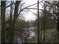
Lake at Ribston Hall
There are two small lakes in the grounds of Ribston Hall [the other is in SE3953], this one being an ornamental lake close to the house. It is sited close to the top of a low hill and is supplied with water from a small beck south of Goldsborough via a pumping house at SE38765448.
Image: © Gordon Hatton
Taken: 22 Dec 2008
0.05 miles
2
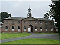
Outbuilding - Ribston Hall - Little Ribston (1)
View of the impressive clock tower outbuilding on the Ribston Hall estate near Little Ribston.
See links below for associated photos.
Image]
Image]
Image: © Tez Exley
Taken: 23 Sep 2023
0.07 miles
3
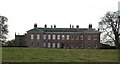
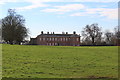
Ribston Hall, north east front
Ribston Hall was built in 1674 for Sir Henry Goodricke and stands on the site of a preceptory of the Knights Templar. The chapel to the left of the house has some 13th century fragments dating back to these times. The Templars owned a large swathe of land in the area, comprising manor, vill and water mill with some 900 acres of arable land and 30 acres of meadow. Much of the surrounding parkland shows evidence of medieval ridge and furrow arable farming. Ribston Hall is also the home of the Ribston Pippin apple which was first grown here from seed brought from near Rouen in 1709. The Ribston Pippin is thought to be the 'parent' of Cox's Orange Pippin apples.
Image: © Gordon Hatton
Taken: 22 Dec 2008
0.08 miles
4
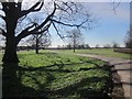
Footpath to Knaresborough at Ribston Park
Image: © John Slater
Taken: 4 Jan 2013
0.09 miles
5
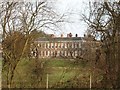
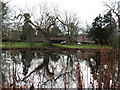
Ribston Hall, south west front
The fifteen bay south west front of this 17th century house can be seen through the trees in winter.
Image: © Gordon Hatton
Taken: 22 Dec 2008
0.09 miles
6
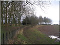
Ribston Park
Footpath 15 49/1/1 follows the drive towards the River Nidd. The park is described at http://list.historicengland.org.uk/resultsingle.aspx?uid=1001071&searchtype=mapsearch .
Image: © Derek Harper
Taken: 6 Apr 2015
0.09 miles
7
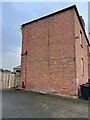
Outbuilding - Ribston Hall - Little Ribston (2)
View of the North East face of an outbuilding on the Ribston Hall Estate near Little Ribston
There is an Ordnance Survey benchmark cut into the brickwork approximately 0.7m from the North angle (Right hand side) and 0.4m AGL.
Close up photo of the benchmark and also an impressive clock tower outbuilding can be seen at the links below.
Image]
Image]
Image: © Tez Exley
Taken: 23 Sep 2023
0.11 miles
8
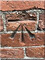
Benchmark - Outbuilding - Ribston Hall - Little Ribston
Close up photo of a rather nice Ordnance Survey cut benchmark on the North East face of an outbuilding on the Ribston Hall Estate near Little Ribston.
Associated photos can be seen at the links below.
Image]
Image]
Image: © Tez Exley
Taken: 23 Sep 2023
0.11 miles