IMAGES TAKEN NEAR TO
Paddock House Lane, WETHERBY, LS22 4BW
Introduction
This page details the photographs taken nearby to Paddock House Lane, LS22 4BW by members of the Geograph project.
The Geograph project started in 2005 with the aim of publishing, organising and preserving representative images for every square kilometre of Great Britain, Ireland and the Isle of Man.

There are currently over 7.5m images from over14,400 individuals and you can help contribute to the project by visiting https://www.geograph.org.uk
Image Map (Loading...)


Getting Data...Please wait
Leaflet Map data © OpenStreetMap
Images are licensed for reuse under creativecommons.org/licenses/by-sa/2.0
Notes
- Clicking on the map will re-center to the selected point.
- The higher the marker number, the further away the image location is from the centre of the postcode.
Image Listing (5 Images Found)
Images are licensed for reuse under creativecommons.org/licenses/by-sa/2.0
Image
Details
Distance
1
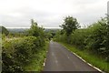
Bridleway following Paddock House Lane
Image: © Mark Anderson
Taken: 21 Aug 2018
0.17 miles
2
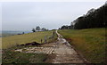
Track beside Old Wives' Wood
Concrete track running parallel to the woods heading towards Paddock House Lane
Image: © Chris Heaton
Taken: 13 Mar 2015
0.18 miles
3
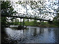
Woodhall Bridge
Woodhall Bridge over the River Wharfe
Nr East Keswick
Image: © Martin Norman
Taken: 11 May 2005
0.21 miles
4
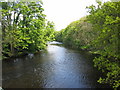
River Wharfe, Nr East Keswick
Woodhall Bridge over the River Wharfe
Nr East Keswick
Image: © Martin Norman
Taken: 11 May 2005
0.21 miles
5
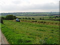
Tractor at work
The tractor is cutting an area of grass along the edge of plantation of willows being grown as a renewable energy crop.
Image: © Ray Woodcraft
Taken: 20 Sep 2006
0.25 miles