IMAGES TAKEN NEAR TO
High Snowden, OTLEY, LS21 2NJ
Introduction
This page details the photographs taken nearby to High Snowden, LS21 2NJ by members of the Geograph project.
The Geograph project started in 2005 with the aim of publishing, organising and preserving representative images for every square kilometre of Great Britain, Ireland and the Isle of Man.

There are currently over 7.5m images from over14,400 individuals and you can help contribute to the project by visiting https://www.geograph.org.uk
Image Map
Images are licensed for reuse under creativecommons.org/licenses/by-sa/2.0
Notes
- Clicking on the map will re-center to the selected point.
- The higher the marker number, the further away the image location is from the centre of the postcode.
Image Listing (16 Images Found)
Images are licensed for reuse under creativecommons.org/licenses/by-sa/2.0
Image
Details
Distance
2
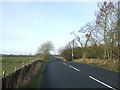
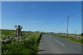
Minor road near Shaw Hall
Heading north towards Blubberhouses.
Image: © JThomas
Taken: 17 Dec 2016
0.05 miles
4
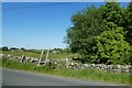
Footpath near Shaws Hall
The footpath leads to Timble from Askwith Moor Road.
Image: © DS Pugh
Taken: 3 Jun 2023
0.07 miles
5
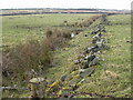
The Eastern slopes of Ellarcarr Pike
The photograph is taken from the Otley to Blubberhouses road close to the entrance to Shaw Hall.
Image: © Derek Parkinson
Taken: 24 Feb 2006
0.08 miles
6
Footpath west of Askwith Moor Road
Askwith Moor Road heads towards Blubberhouses. The footpath crosses Askwith Moor.
Image: © DS Pugh
Taken: 3 Jun 2023
0.09 miles
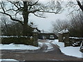
7
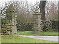
Gateway to Shaw Hall
An impressive gateway from the Otley to Blubberhouses Road.
Image: © Derek Parkinson
Taken: 24 Feb 2006
0.09 miles
8
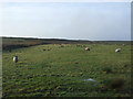
Sheep grazing near Shaw Hall
West of Askwith Moor Road.
Image: © JThomas
Taken: 17 Dec 2016
0.10 miles
9
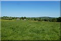
Field north of Shaw Hall
Looking across farmland from Askwith Moor Road.
Image: © DS Pugh
Taken: 3 Jun 2023
0.10 miles
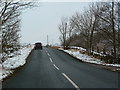
10
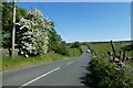
Askwith Moor Road passing Bank Foot
Askwith Moor Road heading up Stoop Hill.
Image: © DS Pugh
Taken: 3 Jun 2023
0.13 miles