IMAGES TAKEN NEAR TO
Gale Lane, OTLEY, LS21 2LU
Introduction
This page details the photographs taken nearby to Gale Lane, LS21 2LU by members of the Geograph project.
The Geograph project started in 2005 with the aim of publishing, organising and preserving representative images for every square kilometre of Great Britain, Ireland and the Isle of Man.

There are currently over 7.5m images from over14,400 individuals and you can help contribute to the project by visiting https://www.geograph.org.uk
Image Map (Loading...)


Getting Data...Please wait
Leaflet Map data © OpenStreetMap
Images are licensed for reuse under creativecommons.org/licenses/by-sa/2.0
Notes
- Clicking on the map will re-center to the selected point.
- The higher the marker number, the further away the image location is from the centre of the postcode.
Image Listing (19 Images Found)
Images are licensed for reuse under creativecommons.org/licenses/by-sa/2.0
Image
Details
Distance
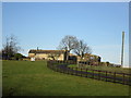
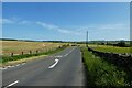
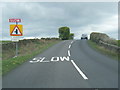
2
Road passing Hilltop Farm
The road between Beckwithshaw and Leathley.
Image: © DS Pugh
Taken: 3 Jun 2023
0.11 miles
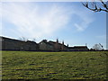
3
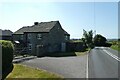
Hilltop Farm
A farm beside the B6161 road between Beckwithshaw and Leathley.
Image: © DS Pugh
Taken: 3 Jun 2023
0.11 miles
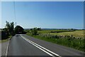
5
B6161 near Pill White Lane
The road between Beckwithshaw and Leathley viewed from the junction with Pill White Lane.
Image: © DS Pugh
Taken: 3 Jun 2023
0.14 miles
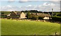
7
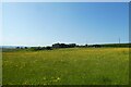
Field near Hilltop Farm
A field of buttercups beside the road between Beckwithshaw and Leathley.
Image: © DS Pugh
Taken: 3 Jun 2023
0.16 miles
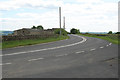
10
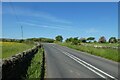
Left hand bend
The B6161 road between Beckwithshaw and Leathley near Hilltop Farm.
Image: © DS Pugh
Taken: 3 Jun 2023
0.20 miles