IMAGES TAKEN NEAR TO
Stainburn, OTLEY, LS21 2LS
Introduction
This page details the photographs taken nearby to LS21 2LS by members of the Geograph project.
The Geograph project started in 2005 with the aim of publishing, organising and preserving representative images for every square kilometre of Great Britain, Ireland and the Isle of Man.

There are currently over 7.5m images from over14,400 individuals and you can help contribute to the project by visiting https://www.geograph.org.uk
Image Map (Loading...)


Getting Data...Please wait
Leaflet Map data © OpenStreetMap
Images are licensed for reuse under creativecommons.org/licenses/by-sa/2.0
Notes
- Clicking on the map will re-center to the selected point.
- The higher the marker number, the further away the image location is from the centre of the postcode.
Image Listing (21 Images Found)
Images are licensed for reuse under creativecommons.org/licenses/by-sa/2.0
Image
Details
Distance
1
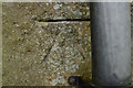
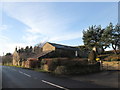
Beck Bottom Farm
There is a cut bench mark on the wall of the house nearest the road. It is next to a drain pipe near the second tree in this photograph. A closer view can be seen here: Image
Image: © Mark Anderson
Taken: 15 May 2011
0.00 miles
2
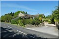
Beck Bottom Manor
A house along the road between Beckwithshaw and Leathley.
Image: © DS Pugh
Taken: 3 Jun 2023
0.02 miles
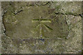
3
Cut Bench Mark, Beck Bottom Farm
Bench Mark Database: http://www.bench-marks.org.uk/bm37949
Image: © Mark Anderson
Taken: 15 May 2011
0.02 miles
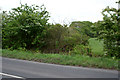
4
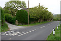
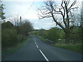
Road passing Beck Bottom Farm
The road between Beckwithshaw and Leathley.
Image: © DS Pugh
Taken: 3 Jun 2023
0.03 miles
7
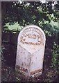
Old Milestone by the B6161, Moorside Bridge, Stainburn
Milestone by the B6161, in parish of Stainburn (Harrogate District), Moorside Bridge, in dip over the West Beck, North West end of bridge.
: KILLING / HALL / 6½ MILES : : DUDLEY HILL KILLINGHALL / HARROGATE / ROAD / STAINBURN : : BRADFORD / 16 MILES :
Grade II listed.
List Entry Number: 1315564 https://historicengland.org.uk/listing/the-list/list-entry/1315564
Milestone Society National ID: YN_BFKH14
Image: © Milestone Society
Taken: Unknown
0.06 miles
8
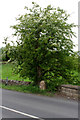
Milepost and Hawthorn, Beck Bottom Farm
Image: © Mark Anderson
Taken: 15 May 2011
0.07 miles
9
Cut Bench Mark near Caps Bridge
Bench Mark Database: http://www.bench-marks.org.uk/bm37948
Image: © Mark Anderson
Taken: 15 May 2011
0.14 miles
10
Bridge Parapet, B6161
This bridge only has a parapet on the south-eastern side of the road. The parapet features a cut bench mark and a closer view can be seen here: Image
Image: © Mark Anderson
Taken: 15 May 2011
0.14 miles