IMAGES TAKEN NEAR TO
Stainburn, OTLEY, LS21 2LQ
Introduction
This page details the photographs taken nearby to LS21 2LQ by members of the Geograph project.
The Geograph project started in 2005 with the aim of publishing, organising and preserving representative images for every square kilometre of Great Britain, Ireland and the Isle of Man.

There are currently over 7.5m images from over14,400 individuals and you can help contribute to the project by visiting https://www.geograph.org.uk
Image Map (Loading...)


Getting Data...Please wait
Leaflet Map data © OpenStreetMap
Images are licensed for reuse under creativecommons.org/licenses/by-sa/2.0
Notes
- Clicking on the map will re-center to the selected point.
- The higher the marker number, the further away the image location is from the centre of the postcode.
Image Listing (67 Images Found)
Images are licensed for reuse under creativecommons.org/licenses/by-sa/2.0
Image
Details
Distance
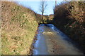
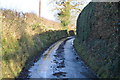
1
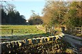
Drive to Woodbottom Farm
You can see part of the fence on the right in Image West Beck runs amongst the trees on the right.
Image: © Derek Harper
Taken: 29 Dec 2016
0.11 miles
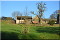

9
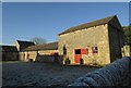
Buildings at Fir Tree Farm
From Dark Lane.
Image: © Derek Harper
Taken: 29 Dec 2016
0.14 miles
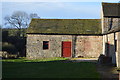
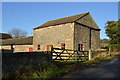
10
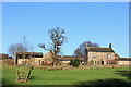
Fir Tree Farm
Farm near Stainburn, North Yorkshire.
Image: © Wayland Smith
Taken: 27 Dec 2015
0.14 miles