IMAGES TAKEN NEAR TO
Moor Lane, OTLEY, LS21 2HT
Introduction
This page details the photographs taken nearby to Moor Lane, LS21 2HT by members of the Geograph project.
The Geograph project started in 2005 with the aim of publishing, organising and preserving representative images for every square kilometre of Great Britain, Ireland and the Isle of Man.

There are currently over 7.5m images from over14,400 individuals and you can help contribute to the project by visiting https://www.geograph.org.uk
Image Map
Images are licensed for reuse under creativecommons.org/licenses/by-sa/2.0
Notes
- Clicking on the map will re-center to the selected point.
- The higher the marker number, the further away the image location is from the centre of the postcode.
Image Listing (5 Images Found)
Images are licensed for reuse under creativecommons.org/licenses/by-sa/2.0
Image
Details
Distance
1
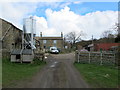
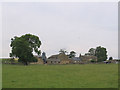
Covey Hall Farm
The yard and buildings at Covey Hall Farm, near Otley.
Image: © Chris Heaton
Taken: 11 Apr 2012
0.02 miles
4
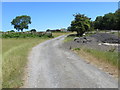
Track (footpath) heading towards Covey Hall Farm
Looking north-eastward.
Image: © Peter Wood
Taken: 4 Jul 2018
0.12 miles
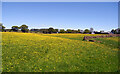
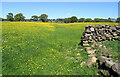
5
Lane Head Farm Clifton
Lane Head Farm near Clifton and Otley in West Yorkshire
Image: © Mick Melvin
Taken: 14 Jul 2005
0.15 miles