IMAGES TAKEN NEAR TO
Old Road, LEEDS, LS17 9HY
Introduction
This page details the photographs taken nearby to Old Road, LS17 9HY by members of the Geograph project.
The Geograph project started in 2005 with the aim of publishing, organising and preserving representative images for every square kilometre of Great Britain, Ireland and the Isle of Man.

There are currently over 7.5m images from over14,400 individuals and you can help contribute to the project by visiting https://www.geograph.org.uk
Image Map
Images are licensed for reuse under creativecommons.org/licenses/by-sa/2.0
Notes
- Clicking on the map will re-center to the selected point.
- The higher the marker number, the further away the image location is from the centre of the postcode.
Image Listing (11 Images Found)
Images are licensed for reuse under creativecommons.org/licenses/by-sa/2.0
Image
Details
Distance

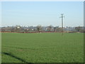
4
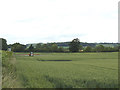
Crop spraying at Red House Farm
This wheat is presumably not organically grown.
Image: © Stephen Craven
Taken: 23 Jun 2020
0.19 miles
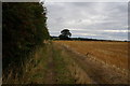
5
Polytunnel at Hawthorne House Farm, Dunkeswick
Protected by a shelter belt of straw bales.
Image: © Christine Johnstone
Taken: 17 Mar 2015
0.21 miles
6
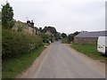
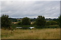
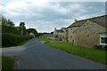
Dunkeswick
Hamlet just to the west of the A61 Leeds/Harrogate Road
Image: © Chris Heaton
Taken: 5 Jun 2006
0.21 miles
9
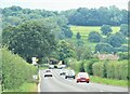
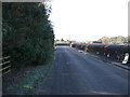
A61 towards Harewood Bridge
A busy road, a narrow bridge ahead, and on this occasion a vehicle crash on the far side at the junction with A659.
Image: © Gordon Hatton
Taken: 27 Aug 2023
0.23 miles
10
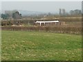
Dunkeswick
Looking along Weeton Lane through Dunkeswick.
Image: © DS Pugh
Taken: 5 Jun 2021
0.25 miles