IMAGES TAKEN NEAR TO
Gelderd Road, LEEDS, LS12 6LG
Introduction
This page details the photographs taken nearby to Gelderd Road, LS12 6LG by members of the Geograph project.
The Geograph project started in 2005 with the aim of publishing, organising and preserving representative images for every square kilometre of Great Britain, Ireland and the Isle of Man.

There are currently over 7.5m images from over14,400 individuals and you can help contribute to the project by visiting https://www.geograph.org.uk
Image Map
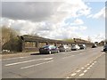
Images are licensed for reuse under creativecommons.org/licenses/by-sa/2.0
Notes
- Clicking on the map will re-center to the selected point.
- The higher the marker number, the further away the image location is from the centre of the postcode.
Image Listing (101 Images Found)
Images are licensed for reuse under creativecommons.org/licenses/by-sa/2.0
Image
Details
Distance
2
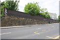
Whitehall Road, Leeds
The wall on the south side of the road looks quite old, and well constructed.
Image: © Stephen Craven
Taken: 30 Apr 2016
0.06 miles
3
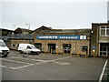
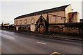
Warehouse on Gelderd Road
This is the Winerite Cash and Carry and Warehousing complex which is sandwiched between the A58 and A62 in South West Leeds. It now stores wines and spirits, but used to be an abattoir
Image: © Chris Heaton
Taken: 8 Jan 2007
0.08 miles
4
Howdens Joinery, Whitehall Road, Leeds
See also Image
Image: © Stephen Craven
Taken: 30 Apr 2016
0.08 miles
5
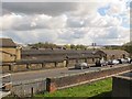
View over Whitehall Road
Looking over a wall onto the roofs of Copley Hill Trading Estate.
Image: © Stephen Craven
Taken: 30 Apr 2016
0.08 miles
6
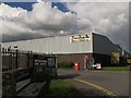
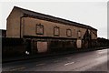
Copley Hill Trading Estate, Whitehall Road East, Leeds
Part of the old Cattle Market which was owned by the Co-op i think...
Image: © Mark Stevenson
Taken: 18 Dec 2016
0.08 miles
7
Whitehall Road at junction with footpath
There is an OS benchmark Image at the base of the stone wall under the pier of the brick wall (left hand side of image) which runs along the footpath which leads over the railway to Wortley Recreation Ground.
Image: © Roger Templeman
Taken: 21 Jun 2016
0.08 miles
8
Copley Hill Trading Estate, Whitehall Road East, Leeds
Part of the old Cattle Market which was owned by the Co-op i think...
Image: © Mark Stevenson
Taken: 18 Dec 2016
0.09 miles
9
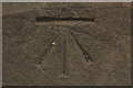
Cut Bench Mark, Whitehall Road
Bench Mark Database: http://www.bench-marks.org.uk/bm76944
Image: © Mark Anderson
Taken: 7 Oct 2016
0.09 miles
10
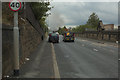
Whitehall Road
There is a cut bench mark on the wall to the left of the photograph and a closer view can be seen here: Image The plume of smoke is from a fire at an industrial unit further along Whitehall Road.
Image: © Mark Anderson
Taken: 7 Oct 2016
0.09 miles