IMAGES TAKEN NEAR TO
Wortley Lane, LEEDS, LS12 1DA
Introduction
This page details the photographs taken nearby to Wortley Lane, LS12 1DA by members of the Geograph project.
The Geograph project started in 2005 with the aim of publishing, organising and preserving representative images for every square kilometre of Great Britain, Ireland and the Isle of Man.

There are currently over 7.5m images from over14,400 individuals and you can help contribute to the project by visiting https://www.geograph.org.uk
Image Map
Images are licensed for reuse under creativecommons.org/licenses/by-sa/2.0
Notes
- Clicking on the map will re-center to the selected point.
- The higher the marker number, the further away the image location is from the centre of the postcode.
Image Listing (206 Images Found)
Images are licensed for reuse under creativecommons.org/licenses/by-sa/2.0
Image
Details
Distance
1
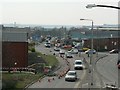
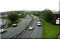
Gelderd Road, Leeds
With traffic approaching the Ingram Distributor Road. Whitehall Road on the right. From the footbridge over the Ingram Distributor Road.
Image: © Rich Tea
Taken: 2 Apr 2007
0.01 miles
4
A643, New Wortley
Seen from the footbridge over the road Image, looking south.
Image: © Stephen Craven
Taken: 19 May 2016
0.02 miles
5
A643 from Footbridge, Gelderd Road
Image: © Betty Longbottom
Taken: 28 Apr 2008
0.02 miles
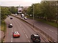
6
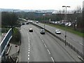
The Ingram Distributor Road, Leeds
The Ingram Distributor Road (A643) links the Armley Gyratory to junction 2 of the M621. This view in the direction of the M621 is from the footbridge over the road by the junction with Gelderd Road.
Image: © Rich Tea
Taken: 2 Apr 2007
0.03 miles
7

Benchmark on Adams Court
Ordnance Survey cut mark benchmark described on the Bench Mark Database at http://www.bench-marks.org.uk/bm76942
Image: © Roger Templeman
Taken: 21 Jun 2016
0.03 miles
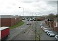
8
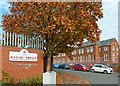
Kildare Terrace
The building in the background is Adams Court, the home of Leeds City Council's Children's Services.
Image: © Mary and Angus Hogg
Taken: 19 Oct 2018
0.03 miles
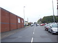
9
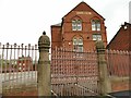
Adams Court, Gelderd Road, Leeds (2)
Originally a typical urban Victorian Board School (Whitehall Road school), built in 1884, architect Richard Adams. The grade II listing (list entry 1375031) refers to it as the 'former Jacob Kramer College' but it had been more recently used by Leeds CIty Council as a children's centre. It has recently (2024) been auctioned off to a new owner but I don't know who this is.
The gates in the foreground are separately listed as 'a remnant of the fine workmanship typical of the Leeds Board Schools'.
Image: © Stephen Craven
Taken: 6 Apr 2024
0.03 miles
10
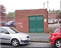
Electricity Substation No 2111 - Whitehall Road
Image: © Betty Longbottom
Taken: 21 May 2012
0.04 miles