IMAGES TAKEN NEAR TO
Cross Ingram Road, LEEDS, LS11 9SE
Introduction
This page details the photographs taken nearby to Cross Ingram Road, LS11 9SE by members of the Geograph project.
The Geograph project started in 2005 with the aim of publishing, organising and preserving representative images for every square kilometre of Great Britain, Ireland and the Isle of Man.

There are currently over 7.5m images from over14,400 individuals and you can help contribute to the project by visiting https://www.geograph.org.uk
Image Map (Loading...)


Getting Data...Please wait
Leaflet Map data © OpenStreetMap
Images are licensed for reuse under creativecommons.org/licenses/by-sa/2.0
Notes
- Clicking on the map will re-center to the selected point.
- The higher the marker number, the further away the image location is from the centre of the postcode.
Image Listing (273 Images Found)
Images are licensed for reuse under creativecommons.org/licenses/by-sa/2.0
Image
Details
Distance
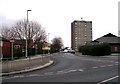
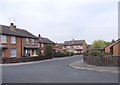
2
Traffic barrier, Cross Ingram Road
An example of 'permeability' in traffic management.
Image: © Stephen Craven
Taken: 6 Apr 2024
0.01 miles
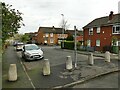
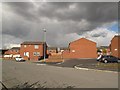
3
Housing off Cross Ingram Road
Modern housing replacing older streets of back-to-back terraces.
Image: © Stephen Craven
Taken: 6 Apr 2024
0.02 miles
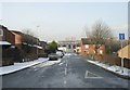
4
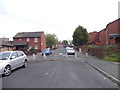
Cross Ingram Road - viewed from Ingram Close
Image: © Betty Longbottom
Taken: 21 May 2012
0.03 miles
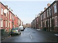
6
Cross Ingram Road - Willoughby Terrace
Image: © Betty Longbottom
Taken: 9 Feb 2009
0.04 miles

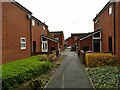
8
New houses, Ingram Road
Old maps show that the area in this view was formerly a street of terraced houses called Willoughby View.
Image: © Stephen Craven
Taken: 30 Apr 2016
0.05 miles
10
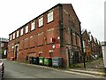
Former factory on Shafton Lane
The 1934 1:2500 map names this as the Vulcan boiler works; the part nearest the road was most recently in use as the Fun Shack (children's party venue) but currently appears disused. A steel flue suggests that other parts of the building may still be in industrial use.
Image: © Stephen Craven
Taken: 6 Apr 2024
0.05 miles