IMAGES TAKEN NEAR TO
St. Anthonys Road, LEEDS, LS11 8DT
Introduction
This page details the photographs taken nearby to St. Anthonys Road, LS11 8DT by members of the Geograph project.
The Geograph project started in 2005 with the aim of publishing, organising and preserving representative images for every square kilometre of Great Britain, Ireland and the Isle of Man.

There are currently over 7.5m images from over14,400 individuals and you can help contribute to the project by visiting https://www.geograph.org.uk
Image Map
Images are licensed for reuse under creativecommons.org/licenses/by-sa/2.0
Notes
- Clicking on the map will re-center to the selected point.
- The higher the marker number, the further away the image location is from the centre of the postcode.
Image Listing (92 Images Found)
Images are licensed for reuse under creativecommons.org/licenses/by-sa/2.0
Image
Details
Distance
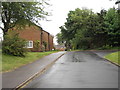
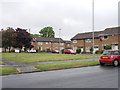
1
Beeston, Leeds, St Andrew's Methodist Church, Old Lane.
Image: © Bill Henderson
Taken: Unknown
0.03 miles
2
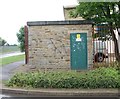
Electricity Substation No 4847 - St Anthony's Road
Image: © Betty Longbottom
Taken: 1 Jun 2012
0.05 miles
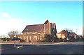
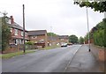
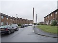
3
St Anthony's Road - looking towards Town Street
Image: © Betty Longbottom
Taken: 1 Jun 2012
0.05 miles
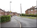
4
Beeston Park Croft - St Anthony's Road
Image: © Betty Longbottom
Taken: 1 Jun 2012
0.05 miles
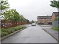
6
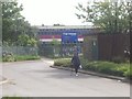
St. Anthony's Road, near Hugh Gaitskell Primary School
Image: © Darrin Antrobus
Taken: 9 Jun 2014
0.09 miles
8
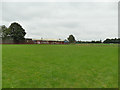
Football pitches behind Redhall Crescent
Image: © Stephen Craven
Taken: 15 Aug 2020
0.10 miles
9
Beeston Park Terrace - looking towards Town Street
Image: © Betty Longbottom
Taken: 1 Jun 2012
0.10 miles