IMAGES TAKEN NEAR TO
Burlington Road, LEEDS, LS11 7DP
Introduction
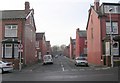
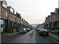
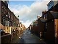
This page details the photographs taken nearby to Burlington Road, LS11 7DP by members of the Geograph project.
The Geograph project started in 2005 with the aim of publishing, organising and preserving representative images for every square kilometre of Great Britain, Ireland and the Isle of Man.

There are currently over 7.5m images from over14,400 individuals and you can help contribute to the project by visiting https://www.geograph.org.uk
Image Map
Images are licensed for reuse under creativecommons.org/licenses/by-sa/2.0
Notes
- Clicking on the map will re-center to the selected point.
- The higher the marker number, the further away the image location is from the centre of the postcode.
Image Listing (197 Images Found)
Images are licensed for reuse under creativecommons.org/licenses/by-sa/2.0
Image
Details
Distance
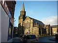
3
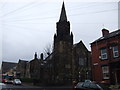
Former Church - Tempest Road
Now converted into flats.
Image: © Betty Longbottom
Taken: 18 Sep 2007
0.03 miles
5
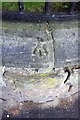
Benchmark on wall of #42 Trentham Street
Ordnance Survey rivet benchmark described on the Bench Mark Database at http://www.bench-marks.org.uk/bm77085
Image: © Roger Templeman
Taken: 18 Jul 2016
0.03 miles
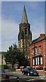
6
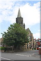
Former Trinity Methodist Church at Tempest Road / Trentham Street junction
There is an OS benchmark Image on top of the wall at its curved corner
Image: © Roger Templeman
Taken: 18 Jul 2016
0.03 miles