IMAGES TAKEN NEAR TO
Cranbrook Avenue, LEEDS, LS11 7AX
Introduction
This page details the photographs taken nearby to Cranbrook Avenue, LS11 7AX by members of the Geograph project.
The Geograph project started in 2005 with the aim of publishing, organising and preserving representative images for every square kilometre of Great Britain, Ireland and the Isle of Man.

There are currently over 7.5m images from over14,400 individuals and you can help contribute to the project by visiting https://www.geograph.org.uk
Image Map
Images are licensed for reuse under creativecommons.org/licenses/by-sa/2.0
Notes
- Clicking on the map will re-center to the selected point.
- The higher the marker number, the further away the image location is from the centre of the postcode.
Image Listing (244 Images Found)
Images are licensed for reuse under creativecommons.org/licenses/by-sa/2.0
Image
Details
Distance
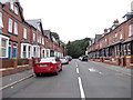
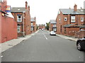
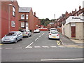
2
Back Cranbrook Avenue - Wickham Street
Image: © Betty Longbottom
Taken: 21 Aug 2012
0.02 miles
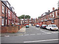
8
Paths at the north end of Cross Flatts Park
Image: © Stephen Craven
Taken: 15 Aug 2020
0.05 miles
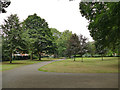
10
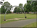
Exercise facility, Cross Flatts Park
An unusual design, presumably the idea is to swing your way along the arc using the grab handles. Good training for strap-hanging on the Tube in London.
Image: © Stephen Craven
Taken: 15 Aug 2020
0.05 miles