IMAGES TAKEN NEAR TO
Brett Gardens, LEEDS, LS11 6TS
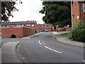
Introduction
This page details the photographs taken nearby to Brett Gardens, LS11 6TS by members of the Geograph project.
The Geograph project started in 2005 with the aim of publishing, organising and preserving representative images for every square kilometre of Great Britain, Ireland and the Isle of Man.

There are currently over 7.5m images from over14,400 individuals and you can help contribute to the project by visiting https://www.geograph.org.uk
Image Map (Loading...)


Getting Data...Please wait
Leaflet Map data © OpenStreetMap
Images are licensed for reuse under creativecommons.org/licenses/by-sa/2.0
Notes
- Clicking on the map will re-center to the selected point.
- The higher the marker number, the further away the image location is from the centre of the postcode.
Image Listing (173 Images Found)
Images are licensed for reuse under creativecommons.org/licenses/by-sa/2.0
Image
Details
Distance
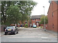
1
Folly Lane - looking towards Lady Pit Lane
Image: © Betty Longbottom
Taken: 21 Aug 2012
0.06 miles
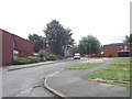
2
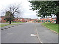
Lady Pit Lane - viewed from Moorville Road
Image: © Betty Longbottom
Taken: 21 Aug 2012
0.06 miles
3
Disused building on Lady Pit Lane.
Beeston.
Image: © Steve Partridge
Taken: 27 Jan 2006
0.06 miles
6
Bismarck Street - viewed from Folly Lane
Image: © Betty Longbottom
Taken: 21 Aug 2012
0.08 miles
7
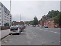
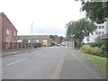
Beeston Road - viewed from Moorville Road
Image: © Betty Longbottom
Taken: 21 Aug 2012
0.09 miles
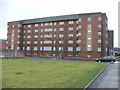
9
Northcote Green - Hunslet Hall Road
Image: © Betty Longbottom
Taken: 21 Aug 2012
0.09 miles
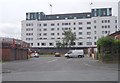
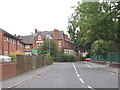
10
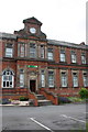
Hillside Enterprise Centre, Beeston Road
There is an OS benchmark Image on the wall of the building (formerly a school) right of the former infants' entrance
Image: © Roger Templeman
Taken: 9 Jul 2016
0.09 miles