IMAGES TAKEN NEAR TO
Linden Place, LEEDS, LS11 6HE
Introduction
This page details the photographs taken nearby to Linden Place, LS11 6HE by members of the Geograph project.
The Geograph project started in 2005 with the aim of publishing, organising and preserving representative images for every square kilometre of Great Britain, Ireland and the Isle of Man.

There are currently over 7.5m images from over14,400 individuals and you can help contribute to the project by visiting https://www.geograph.org.uk
Image Map
Images are licensed for reuse under creativecommons.org/licenses/by-sa/2.0
Notes
- Clicking on the map will re-center to the selected point.
- The higher the marker number, the further away the image location is from the centre of the postcode.
Image Listing (215 Images Found)
Images are licensed for reuse under creativecommons.org/licenses/by-sa/2.0
Image
Details
Distance


8
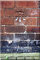
Benchmark on #16 Linden Street
Ordnance Survey cut mark benchmark described on the Bench Mark Database at http://www.bench-marks.org.uk/bm77072
Image: © Roger Templeman
Taken: 9 Jul 2016
0.03 miles
9
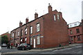
Junction of Linden Street and Linden Road
There is an OS benchmark Image at the middle of the blank end face of the houses, left of a green cabinet
Image: © Roger Templeman
Taken: 9 Jul 2016
0.03 miles
10

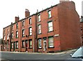
Crossland Terrace - Dewsbury Road
Image: © Betty Longbottom
Taken: 15 Dec 2008
0.03 miles