IMAGES TAKEN NEAR TO
Lockwood Park, LEEDS, LS11 5UX
Introduction
This page details the photographs taken nearby to Lockwood Park, LS11 5UX by members of the Geograph project.
The Geograph project started in 2005 with the aim of publishing, organising and preserving representative images for every square kilometre of Great Britain, Ireland and the Isle of Man.

There are currently over 7.5m images from over14,400 individuals and you can help contribute to the project by visiting https://www.geograph.org.uk
Image Map (Loading...)


Getting Data...Please wait
Leaflet Map data © OpenStreetMap
Images are licensed for reuse under creativecommons.org/licenses/by-sa/2.0
Notes
- Clicking on the map will re-center to the selected point.
- The higher the marker number, the further away the image location is from the centre of the postcode.
Image Listing (78 Images Found)
Images are licensed for reuse under creativecommons.org/licenses/by-sa/2.0
Image
Details
Distance
1
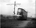
Feltham car at Parkside
The No 12 Middleton route which was the showpiece of the Leeds tram system, mostly followed the route of a railway laid by contractors when the Middleton estate was being constructed. Cars from the City ran on-street along Dewsbury Road and the Moor Road. At the end of Moor Road they left the street and ran along tracks through waste ground past Parkside where supporters of Hunslet Rugby League club would descend, then climbing to reach the verdant splendours of Middleton Woods before terminating at Lingwell Road. Above, car 518 has just passed Parkside, (the Rugby posts are just visible, left background) and is climbing towards the woods.
Image: © Dr Neil Clifton
Taken: 28 Mar 1957
0.00 miles
2
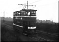
Towards the woods
Showboat car 192 climbs towards Middleton Woods
Image: © Dr Neil Clifton
Taken: 21 Mar 1959
0.04 miles
3
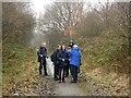
On the old tramway trackbed to Middleton
This high speed tramway on reserved track was authorised in 1919 and opened in 1925 to link Leeds with the new housing estates at Middleton. For much of its length it paralleled the Middleton Railway, and this section is now a public footpath.
Dr Clifton's photos http://www.geograph.org.uk/search.php?i=82211322 show how the line looked in its final years.
A slightly damp group of Geograph members are exploring the area as part of the Geograph 13th birthday meet.
Image: © Alan Murray-Rust
Taken: 10 Mar 2018
0.04 miles
4

Cars do not stop by request
The two girls and the dog are not intending passengers for Showboat car No 202 as it speeds down from Middleton woods. There is no request stop at this point
Image: © Dr Neil Clifton
Taken: 21 Mar 1959
0.06 miles
6
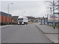
Parkside Lane - viewed from Lockwood Way
Image: © Betty Longbottom
Taken: 22 Feb 2013
0.09 miles
7
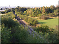
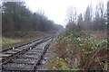
Middleton Railway north of John Charles Approach
Looking north towards the city centre about 4km away. The LNER's Hunslet Branch railway used to cross the Middleton Railway roughly in the centre of this photo but there is no trace of it now.
Image: © Stephen Craven
Taken: 18 Aug 2016
0.09 miles
8
Parkside Lane - viewed from Lockwood Way
Image: © Betty Longbottom
Taken: 22 Feb 2013
0.10 miles
9
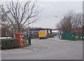
Footpath to Parkside Lane
The path links the John Charles Approach bridge over the Middleton Railway to the Parkside Lane industrial estate.
Image: © Stephen Craven
Taken: 18 Aug 2016
0.10 miles
10
Merging lines
The Dartmouth Branch joins the main Middleton Railway.
Image: © DS Pugh
Taken: 10 Mar 2018
0.11 miles