IMAGES TAKEN NEAR TO
Dewsbury Road, LEEDS, LS11 5NN
Introduction
This page details the photographs taken nearby to Dewsbury Road, LS11 5NN by members of the Geograph project.
The Geograph project started in 2005 with the aim of publishing, organising and preserving representative images for every square kilometre of Great Britain, Ireland and the Isle of Man.

There are currently over 7.5m images from over14,400 individuals and you can help contribute to the project by visiting https://www.geograph.org.uk
Image Map (Loading...)


Getting Data...Please wait
Leaflet Map data © OpenStreetMap
Images are licensed for reuse under creativecommons.org/licenses/by-sa/2.0
Notes
- Clicking on the map will re-center to the selected point.
- The higher the marker number, the further away the image location is from the centre of the postcode.
Image Listing (169 Images Found)
Images are licensed for reuse under creativecommons.org/licenses/by-sa/2.0
Image
Details
Distance
1
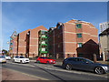
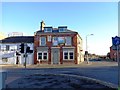
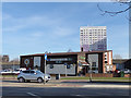
Flats on Dewsbury Road
See Image for a closer view of the clock at the end, and reference to the clothing factory formerly on this site.
Image: © Stephen Craven
Taken: 24 Feb 2018
0.01 miles
2
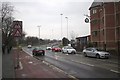
Wakefield Road near Admiral Street
Looking north along Wakefield Road as it approaches the junction with Admiral Street on the right. The clock on the building to the right appears to be suspended from sewing needles, probably a reference to Maple Clothing Co Ltd whose factory once stood here. The Spinning Wheel public house can just be seen beyond the estate agents' boards.
Image: © Mark Anderson
Taken: 10 Mar 2018
0.01 miles
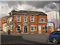
3
The Spinning Wheel - Admiral Street
Image: © Betty Longbottom
Taken: 18 Sep 2007
0.02 miles
4
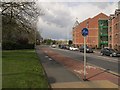
Segregated cycle path, Dewsbury Road
A high quality facility compared with much provision elsewhere in the city.
Image: © Stephen Craven
Taken: 30 Apr 2016
0.02 miles
5
The Former Junction Public House, now converted to apartments
Image: © Bill Henderson
Taken: 2 Dec 2012
0.02 miles
7
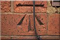
Cut bench mark, The Junction public house, Dewsbury Road
Bench Mark Database: http://www.bench-marks.org.uk/bm77168
Image: © Mark Anderson
Taken: 10 Mar 2018
0.02 miles
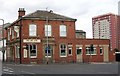
8
The Junction public house (disused), Dewsbury Road
Located at the junction of Dewsbury Road and Moor Road. There is a cut bench mark on the wall at the left side of the pub and a closer view can be seen here: Image
Image: © Mark Anderson
Taken: 10 Mar 2018
0.02 miles
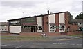
9
The Spinning Wheel, Dewsbury Road
A typical 'estate' pub, although in this instance on the main road, on the corner of Admiral Street. An old map from the 1930s shows a 'blouse factory' on the other side of Admiral Street, which may have inspired the name. A John Smith's house.
Image: © Stephen Craven
Taken: 24 Feb 2018
0.03 miles
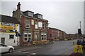
10
The Junction, Hunslet - closed
The pub took its name from its location at the corner of Moor Road and Dewsbury Road. It was still open in 2007 Image but closed by 2016 and two prominent dormer windows have been added by the new owner.
Image: © Stephen Craven
Taken: 30 Apr 2016
0.03 miles