IMAGES TAKEN NEAR TO
Dewsbury Road, LEEDS, LS11 5EG
Introduction
This page details the photographs taken nearby to Dewsbury Road, LS11 5EG by members of the Geograph project.
The Geograph project started in 2005 with the aim of publishing, organising and preserving representative images for every square kilometre of Great Britain, Ireland and the Isle of Man.

There are currently over 7.5m images from over14,400 individuals and you can help contribute to the project by visiting https://www.geograph.org.uk
Image Map (259 Images)


Getting Data...Please wait
Leaflet Map data © OpenStreetMap
Images are licensed for reuse under creativecommons.org/licenses/by-sa/2.0
Notes
- Clicking on the map will re-center to the selected point.
- The higher the marker number, the further away the image location is from the centre of the postcode.
Image Listing (259 Images Found)
Images are licensed for reuse under creativecommons.org/licenses/by-sa/2.0
Image
Details
Distance
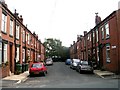
1
Dewsbury Road shops
A short parade of shops on the east side of the road including a convenience store with sub post office, hairstylist and solicitor (there are a few other units just out of shot to the right).
Image: © Stephen Craven
Taken: 30 Apr 2016
0.02 miles
2
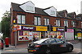
Post Office/shop on Dewsbury Road at Burton Avenue junction
There is an OS benchmark Image on the left hand side of the post office near its front corner
Image: © Roger Templeman
Taken: 18 Jul 2016
0.02 miles
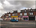
3
Dewsbury Road post office and Premier stores
Apart from the signage above the shop and the name of the hair salon next door, not much has changed since my 2016 view Image But pavement parking as seen here has become a much more common practice in recent years; it is legal in most of England but that is currently under review.
Image: © Stephen Craven
Taken: 27 Jan 2024
0.03 miles
4
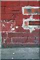
Benchmark on #163 Dewsbury Road
Ordnance Survey cut mark benchmark described on the Bench Mark Database at http://www.bench-marks.org.uk/bm77169
Image: © Roger Templeman
Taken: 18 Jul 2016
0.03 miles
5
Election poster, Dobson Avenue, Hunslet
Whatever your own politics, Mr Carlisle the Green candidate in a local election seemed to have his name everywhere.
Dobson Avenue is one of several streets of terraced housing off Burton Avenue, presumably named after Richard Dobson whose maltings was the main industrial site in the locality.
Image: © Stephen Craven
Taken: 30 Apr 2016
0.04 miles
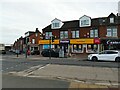
6
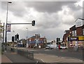
Dewsbury Road - puffin crossing
Located outside the One Stop Centre Image The repeater light above the traffic lane is a Continental practice that seems to have gained popularity in the UK in recent years.
Image: © Stephen Craven
Taken: 30 Apr 2016
0.04 miles
7

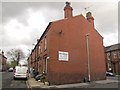
Park Lane College - viewed from Burton Avenue
Image: © Betty Longbottom
Taken: 15 Sep 2008
0.05 miles
8
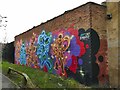
Mural near Dewsbury Road Community Hub
The mural on the back wall of the Conservative Club consists of six mice in the style of Walt Disney, but credited to Fat Cap Sprays.
Image: © Stephen Craven
Taken: 27 Jan 2024
0.05 miles
9
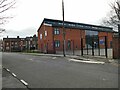
Hunslet Moor Primary School, Burton Avenue Entrance
The building seen here has been erected since 2016 on the site of the former Park Lane College Image For the other buildings of the primary school, see Image
Image: © Stephen Craven
Taken: 27 Jan 2024
0.05 miles