IMAGES TAKEN NEAR TO
LEEDS, LS10 9EH
Introduction
This page details the photographs taken nearby to LS10 9EH by members of the Geograph project.
The Geograph project started in 2005 with the aim of publishing, organising and preserving representative images for every square kilometre of Great Britain, Ireland and the Isle of Man.

There are currently over 7.5m images from over14,400 individuals and you can help contribute to the project by visiting https://www.geograph.org.uk
Image Map
Images are licensed for reuse under creativecommons.org/licenses/by-sa/2.0
Notes
- Clicking on the map will re-center to the selected point.
- The higher the marker number, the further away the image location is from the centre of the postcode.
Image Listing (106 Images Found)
Images are licensed for reuse under creativecommons.org/licenses/by-sa/2.0
Image
Details
Distance
1
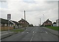
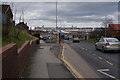
West Grange Drive - Belle Isle Road
Image: © Betty Longbottom
Taken: 1 Apr 2009
0.01 miles
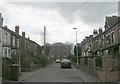
3
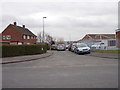
West Grange Garth - West Grange Drive
Image: © Betty Longbottom
Taken: 22 Feb 2013
0.03 miles
4

East Grange Drive - Belle Isle Road
Image: © Betty Longbottom
Taken: 1 Apr 2009
0.04 miles
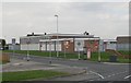
5
Electricity Substation No 2198 - Belle Isle Road
Image: © Betty Longbottom
Taken: 22 Feb 2013
0.04 miles
6
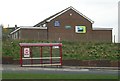
West Grange Church - viewed from Belle Isle Road
Image: © Betty Longbottom
Taken: 1 Apr 2009
0.04 miles
9
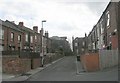
Back Nursery Mount - South View Road
Image: © Betty Longbottom
Taken: 1 Apr 2009
0.05 miles
