IMAGES TAKEN NEAR TO
Murray Avenue, LEEDS, LS10 4GS
Introduction
This page details the photographs taken nearby to Murray Avenue, LS10 4GS by members of the Geograph project.
The Geograph project started in 2005 with the aim of publishing, organising and preserving representative images for every square kilometre of Great Britain, Ireland and the Isle of Man.

There are currently over 7.5m images from over14,400 individuals and you can help contribute to the project by visiting https://www.geograph.org.uk
Image Map
Images are licensed for reuse under creativecommons.org/licenses/by-sa/2.0
Notes
- Clicking on the map will re-center to the selected point.
- The higher the marker number, the further away the image location is from the centre of the postcode.
Image Listing (93 Images Found)
Images are licensed for reuse under creativecommons.org/licenses/by-sa/2.0
Image
Details
Distance
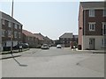
2
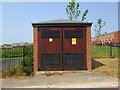
Electricity Substation No 112 - New Forest Way
Image: © Betty Longbottom
Taken: 5 Jul 2013
0.04 miles
5
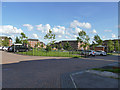
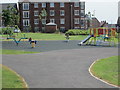
Play area, Leeds New Forest Village
This is an urban square including a small public park with play equipment Image There are larger green spaces for ball games on the edges of the estate.
Image: © Stephen Craven
Taken: 2 Aug 2020
0.06 miles